Tondabayashichō geodata
Tondabayashichō (Ōsaka) is a seat of a second-order administrative division; located in Japan in Asia/Tokyo (GMT+9) time zone. With population of 132,873 people, there are 153 cities with bigger population in this country. Compared to other cities in Japan, 72.4% of cities are located further ↑North; 65.5% of cities are located further →East and 68% of cities have lower elevation than Tondabayashichō. Note1


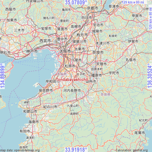
Tondabayashichō GPS coordinates[2]
34° 30' 2.34" North, 135° 36' 7.596" East
| Map corner | latitude | longitude |
|---|---|---|
| Upper-left | 35.07809°, | 134.89899° |
| Center: | 34.50065°, | 135.60211° |
| Lower-right: | 33.91918°, | 136.30524° |
| Map W x H: | 128.9×128.9 km | = 80.1×80.1mi |
| max Lat: | 45.40944° ⇑72.4% North |
| Tondabayashichō: | 34.50065° |
| min Lat: | ⇓27.6% South 24.34478° |
| min Long | Tondabayashich� | max Long |
| 123° | 135.60211° | 145.575° |
| W 34.5%⇐ | ⇒65.5% E |
Elevation
Elevation of Tondabayashichō is 66 m = 217 ft, and this is 18.6 m = 61 ft below average elevation for this country.
| Max E: |
1086 m = 3563 ft | 32% |
| Avg. | 84.6 m = 278 ft | |
| Tondabayashichō | 66 m = 217 ft | |
Min E: |
-2 m = -7 ft | 68% |
See also: Tondabayashichō elevation on elevation.city.
Geographical zone
Tondabayashichō is located in North temperate zone (between Tropic of Cancer and the Arctic Circle). Distance of this Northern Tropic circle is 1230.2 km =764.4 mi to South.| Distance of | km | miles | from Tondabayashichō |
|---|---|---|---|
| North Pole | 6170.9 | 3834.4 | to North |
| Arctic Circle | 3565.1 | 2215.2 | to North |
| Tropic Cancer | 1230.2 | 764.4 | to South |
| Equator | 3836.1 | 2383.6 | to South |


Nearby cities:
15 places around Tondabayashichō: (largest is in red/bold)
• Fujiidera
7.5 km =4.7 mi,  356°
356°
• Gose
13.3 km =8.3 mi,  115°
115°
• Habikino
5.9 km =3.7 mi,  350°
350°
• Izumi
15.6 km =9.7 mi,  262°
262°
• Kashiba
10.5 km =6.5 mi,  68°
68°
• Kashihara
9.3 km =5.8 mi,  8°
8°
• Kashihara-shi
17.5 km =10.9 mi,  86°
86°
• Katsuragi
8.9 km =5.5 mi,  100°
100°
• Kawachi-Nagano
6.9 km =4.3 mi,  194°
194°
• Matsubara
8.8 km =5.5 mi,  326°
326°
• Sakai
15.4 km =9.6 mi,  306°
306°
• Takaishi
15.6 km =9.7 mi,  276°
276°
• Yamato-Takada
13.7 km =8.5 mi,  82°
82°
• Yao
12.9 km =8 mi, 359°
• Ōsaka-sayama
4.8 km =3 mi, 262°
Sources, notices
• [Note1] Compared only with cities in Japan existing in our database
• [Src1] Map data: © OpenStreetMap contributors (CC-BY-SA)
• [Src2] Other city data from geonames.org with taken over terms of usage.
• [Src3] Geographical zone / Annual Mean Temperature by Robert A. Rohde @ Wikipedia
