Matsubara geodata
Matsubara (Ōsaka) is a seat of a second-order administrative division; located in Japan in Asia/Tokyo (GMT+9) time zone. With population of 130,855 people, there are 161 cities with bigger population in this country. Compared to other cities in Japan, 71.1% of cities are located further ↑North; 66.6% of cities are located further →East and 54% of cities have higher elevation than Matsubara. Note1


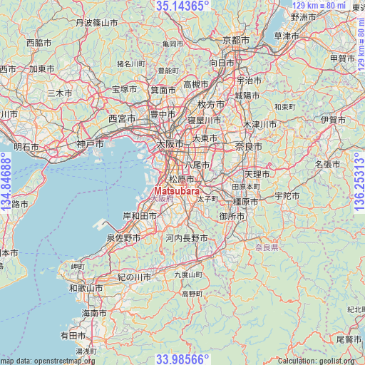
Matsubara GPS coordinates[2]
34° 34' 0.012" North, 135° 33' 0" East
| Map corner | latitude | longitude |
|---|---|---|
| Upper-left | 35.14365°, | 134.84688° |
| Center: | 34.56667°, | 135.55° |
| Lower-right: | 33.98566°, | 136.25313° |
| Map W x H: | 128.8×128.8 km | = 80×80mi |
| max Lat: | 45.40944° ⇑71.1% North |
| Matsubara: | 34.56667° |
| min Lat: | ⇓28.9% South 24.34478° |
| min Long | Matsubara | max Long |
| 123° | 135.55° | 145.575° |
| W 33.4%⇐ | ⇒66.6% E |
Elevation
Elevation of Matsubara is 24 m = 79 ft, and this is 60.6 m = 199 ft below average elevation for this country.
| Max E: |
1086 m = 3563 ft | 54% |
| Avg. | 84.6 m = 278 ft | |
| Matsubara | 24 m = 79 ft | |
Min E: |
-2 m = -7 ft | 46% |
See also: Matsubara elevation on elevation.city.
Geographical zone
Matsubara is located in North temperate zone (between Tropic of Cancer and the Arctic Circle). Distance of this Northern Tropic circle is 1237.5 km =768.9 mi to South.| Distance of | km | miles | from Matsubara |
|---|---|---|---|
| North Pole | 6163.6 | 3829.9 | to North |
| Arctic Circle | 3557.7 | 2210.7 | to North |
| Tropic Cancer | 1237.5 | 768.9 | to South |
| Equator | 3843.5 | 2388.2 | to South |


Nearby cities:
15 places around Matsubara: (largest is in red/bold)
• Fujiidera
4.3 km =2.7 mi,  88°
88°
• Habikino
4.1 km =2.5 mi,  112°
112°
• Higashi-ōsaka
11.5 km =7.1 mi,  15°
15°
• Izumi
14.1 km =8.8 mi,  229°
229°
• Izumiōtsu
15.6 km =9.7 mi,  241°
241°
• Kashiba
15 km =9.3 mi,  103°
103°
• Kashihara
6.4 km =4 mi,  73°
73°
• Katsuragi
16.2 km =10.1 mi,  123°
123°
• Kawachi-Nagano
14.3 km =8.9 mi,  167°
167°
• Osaka
14.8 km =9.2 mi,  342°
342°
• Sakai
7.9 km =4.9 mi,  283°
283°
• Takaishi
12 km =7.5 mi, 242°
• Tondabayashichō
8.8 km =5.5 mi,  146°
146°
• Yao
7.2 km =4.5 mi,  39°
39°
• Ōsaka-sayama
7.9 km =4.9 mi,  179°
179°
Sources, notices
• [Note1] Compared only with cities in Japan existing in our database
• [Src1] Map data: © OpenStreetMap contributors (CC-BY-SA)
• [Src2] Other city data from geonames.org with taken over terms of usage.
• [Src3] Geographical zone / Annual Mean Temperature by Robert A. Rohde @ Wikipedia
