Kashiba geodata
Kashiba (Nara) is a seat of a second-order administrative division; located in Japan in Asia/Tokyo (GMT+9) time zone. In our database, there are 767 cities with bigger population. Compared to other cities in Japan, 71.7% of cities are located further ↑North; 63.9% of cities are located further →East and 65.4% of cities have lower elevation than Kashiba. Note1


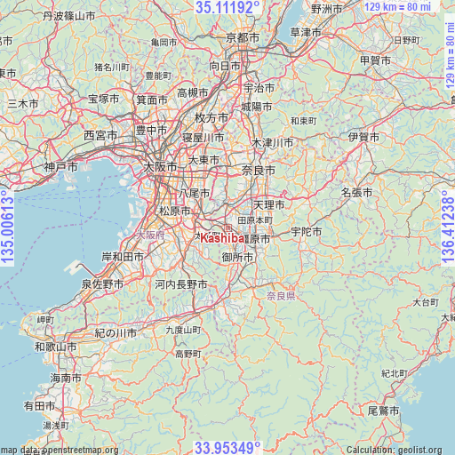
Kashiba GPS coordinates[2]
34° 32' 4.992" North, 135° 42' 33.3" East
| Map corner | latitude | longitude |
|---|---|---|
| Upper-left | 35.11192°, | 135.00613° |
| Center: | 34.53472°, | 135.70925° |
| Lower-right: | 33.95349°, | 136.41238° |
| Map W x H: | 128.8×128.8 km | = 80×80mi |
| max Lat: | 45.40944° ⇑71.7% North |
| Kashiba: | 34.53472° |
| min Lat: | ⇓28.3% South 24.34478° |
| min Long | Kashiba | max Long |
| 123° | 135.70925° | 145.575° |
| W 36.1%⇐ | ⇒63.9% E |
Elevation
Elevation of Kashiba is 58 m = 190 ft, and this is 26.6 m = 87 ft below average elevation for this country.
| Max E: |
1086 m = 3563 ft | 34.6% |
| Avg. | 84.6 m = 278 ft | |
| Kashiba | 58 m = 190 ft | |
Min E: |
-2 m = -7 ft | 65.4% |
See also: Japan elevation on elevation.city.
Geographical zone
Kashiba is located in North temperate zone (between Tropic of Cancer and the Arctic Circle). Distance of this Northern Tropic circle is 1234 km =766.8 mi to South.| Distance of | km | miles | from Kashiba |
|---|---|---|---|
| North Pole | 6167.2 | 3832.1 | to North |
| Arctic Circle | 3561.3 | 2212.9 | to North |
| Tropic Cancer | 1234 | 766.8 | to South |
| Equator | 3839.9 | 2386 | to South |


Nearby cities:
15 places around Kashiba: (largest is in red/bold)
• Fujiidera
10.9 km =6.8 mi,  289°
289°
• Gose
9.7 km =6 mi,  166°
166°
• Habikino
11 km =6.8 mi,  280°
280°
• Hōryūji
9 km =5.6 mi,  16°
16°
• Kashihara
10.1 km =6.3 mi,  302°
302°
• Kashihara-shi
8.2 km =5.1 mi,  110°
110°
• Katsuragi
5.6 km =3.5 mi,  191°
191°
• Matsubara
15 km =9.3 mi, 283°
• Sakurai
13.5 km =8.4 mi, 106°
• Tawaramoto
8 km =5 mi,  74°
74°
• Tenri
12.6 km =7.8 mi,  64°
64°
• Tondabayashichō
10.5 km =6.5 mi,  248°
248°
• Yamato-Takada
4.2 km =2.6 mi,  118°
118°
• Yamatokōriyama
9.8 km =6.1 mi,  34°
34°
• Yao
13.5 km =8.4 mi,  312°
312°
Sources, notices
• [Note1] Compared only with cities in Japan existing in our database
• [Src1] Map data: © OpenStreetMap contributors (CC-BY-SA)
• [Src2] Other city data from geonames.org with taken over terms of usage.
• [Src3] Geographical zone / Annual Mean Temperature by Robert A. Rohde @ Wikipedia
