Sayama geodata
Sayama (Saitama) is a seat of a second-order administrative division; located in Japan in Asia/Tokyo (GMT+9) time zone. With population of 160,843 people, there are 127 cities with bigger population in this country. Compared to other cities in Japan, 63.8% of cities are located further ↓South; 66.6% of cities are located further ←West and 72.2% of cities have lower elevation than Sayama. Note1


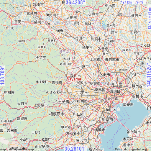
Sayama GPS coordinates[2]
35° 51' 10.62" North, 139° 24' 43.632" East
| Map corner | latitude | longitude |
|---|---|---|
| Upper-left | 36.4208°, | 138.709° |
| Center: | 35.85295°, | 139.41212° |
| Lower-right: | 35.28101°, | 140.11525° |
| Map W x H: | 126.7×126.7 km | = 78.7×78.7mi |
| max Lat: | 45.40944° ⇑36.2% North |
| Sayama: | 35.85295° |
| min Lat: | ⇓63.8% South 24.34478° |
| min Long | Sayama | max Long |
| 123° | 139.41212° | 145.575° |
| W 66.6%⇐ | ⇒33.4% E |
Elevation
Elevation of Sayama is 81 m = 266 ft, and this is 3.6 m = 12 ft below average elevation for this country.
| Max E: |
1086 m = 3563 ft | 27.8% |
| Avg. | 84.6 m = 278 ft | |
| Sayama | 81 m = 266 ft | |
Min E: |
-2 m = -7 ft | 72.2% |
See also: Sayama elevation on elevation.city.
Geographical zone
Sayama is located in North temperate zone (between Tropic of Cancer and the Arctic Circle). Distance of this Northern Tropic circle is 1380.6 km =857.9 mi to South.| Distance of | km | miles | from Sayama |
|---|---|---|---|
| North Pole | 6020.6 | 3741 | to North |
| Arctic Circle | 3414.7 | 2121.8 | to North |
| Tropic Cancer | 1380.6 | 857.9 | to South |
| Equator | 3986.5 | 2477.1 | to South |


Nearby cities:
15 places around Sayama: (largest is in red/bold)
• Fujimi
12.9 km =8 mi,  92°
92°
• Fujimino
9.3 km =5.8 mi,  84°
84°
• Hannō
8.5 km =5.3 mi,  269°
269°
• Hidaka
8.4 km =5.2 mi,  327°
327°
• Higashimurayama
12.1 km =7.5 mi,  155°
155°
• Higashiyamato
10.5 km =6.5 mi, 163°
• Higashiyamato
11.5 km =7.1 mi,  172°
172°
• Iruma
5.6 km =3.5 mi,  225°
225°
• Kamifukuoka
9.4 km =5.8 mi, 76°
• Kawagoe
9 km =5.6 mi,  46°
46°
• Musashimurayama
12.4 km =7.7 mi, 174°
• Sakado
11.8 km =7.3 mi,  349°
349°
• Tokorozawa
7.9 km =4.9 mi,  139°
139°
• Tsurugashima
11.9 km =7.4 mi,  355°
355°
• Ōi
9.7 km =6 mi, 91°
Sources, notices
• [Note1] Compared only with cities in Japan existing in our database
• [Src1] Map data: © OpenStreetMap contributors (CC-BY-SA)
• [Src2] Other city data from geonames.org with taken over terms of usage.
• [Src3] Geographical zone / Annual Mean Temperature by Robert A. Rohde @ Wikipedia
