Tadotsu geodata
Tadotsu (Kagawa) is a populated place; located in Japan in Asia/Tokyo (GMT+9) time zone. With population of 23,514 people, there are 631 cities with bigger population in this country. Compared to other cities in Japan, 76.2% of cities are located further ↑North; 76.3% of cities are located further →East and 93.5% of cities have higher elevation than Tadotsu. Note1


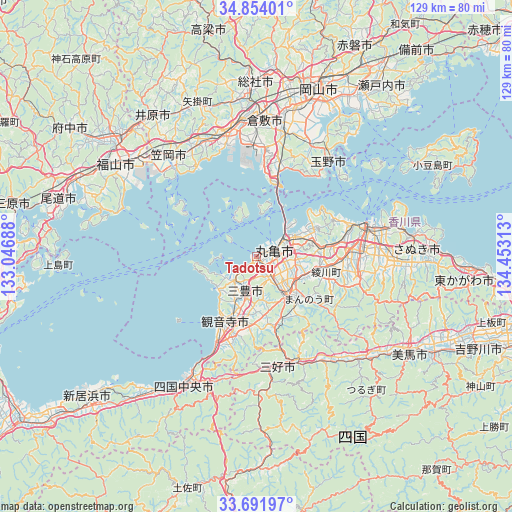
Tadotsu GPS coordinates[2]
34° 16' 30" North, 133° 45' 0" East
| Map corner | latitude | longitude |
|---|---|---|
| Upper-left | 34.85401°, | 133.04688° |
| Center: | 34.275°, | 133.75° |
| Lower-right: | 33.69197°, | 134.45313° |
| Map W x H: | 129.2×129.2 km | = 80.3×80.3mi |
| max Lat: | 45.40944° ⇑76.2% North |
| Tadotsu: | 34.275° |
| min Lat: | ⇓23.8% South 24.34478° |
| min Long | Tadotsu | max Long |
| 123° | 133.75° | 145.575° |
| W 23.7%⇐ | ⇒76.3% E |
Elevation
Elevation of Tadotsu is 4 m = 13 ft, and this is 80.6 m = 264 ft below average elevation for this country.
| Max E: |
1086 m = 3563 ft | 93.5% |
| Avg. | 84.6 m = 278 ft | |
| Tadotsu | 4 m = 13 ft | |
Min E: |
-2 m = -7 ft | 6.5% |
See also: Japan elevation on elevation.city.
Geographical zone
Tadotsu is located in North temperate zone (between Tropic of Cancer and the Arctic Circle). Distance of this Northern Tropic circle is 1205.1 km =748.8 mi to South.| Distance of | km | miles | from Tadotsu |
|---|---|---|---|
| North Pole | 6196 | 3850 | to North |
| Arctic Circle | 3590.2 | 2230.8 | to North |
| Tropic Cancer | 1205.1 | 748.8 | to South |
| Equator | 3811 | 2368 | to South |


Nearby cities:
15 places around Tadotsu: (largest is in red/bold)
• Asakuchi
31.9 km =19.8 mi,  334°
334°
• Ikedachō
27.9 km =17.3 mi,  169°
169°
• Kamogatachō-kamogata
32.7 km =20.3 mi, 333°
• Kan’onji
24.6 km =15.3 mi,  202°
202°
• Kan’onjichō
19 km =11.8 mi,  210°
210°
• Kasaoka
34.2 km =21.3 mi,  318°
318°
• Kawanoechō
32.8 km =20.4 mi, 208°
• Kurashiki
34.3 km =21.3 mi,  2°
2°
• Marugame
3.2 km =2 mi,  73°
73°
• Mitoyo
10 km =6.2 mi,  224°
224°
• Sakaidechō
9.5 km =5.9 mi,  55°
55°
• Shikokuchūō
38.1 km =23.7 mi, 209°
• Takamatsu
28.3 km =17.6 mi,  76°
76°
• Tamano
32.4 km =20.1 mi,  33°
33°
• Zentsujichó
5.9 km =3.7 mi,  154°
154°
Sources, notices
• [Note1] Compared only with cities in Japan existing in our database
• [Src1] Map data: © OpenStreetMap contributors (CC-BY-SA)
• [Src2] Other city data from geonames.org with taken over terms of usage.
• [Src3] Geographical zone / Annual Mean Temperature by Robert A. Rohde @ Wikipedia
