Takamatsu geodata
Takamatsu (Kagawa) is a seat of a first-order administrative division; located in Japan in Asia/Tokyo (GMT+9) time zone. With population of 334,223 people, there are 58 cities with bigger population in this country. Compared to other cities in Japan, 75.5% of cities are located further ↑North; 74.9% of cities are located further →East and 62.8% of cities have higher elevation than Takamatsu. Note1


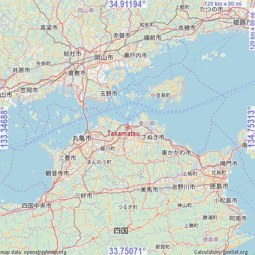
Takamatsu GPS coordinates[2]
34° 19' 59.988" North, 134° 3' 0" East
| Map corner | latitude | longitude |
|---|---|---|
| Upper-left | 34.91194°, | 133.34688° |
| Center: | 34.33333°, | 134.05° |
| Lower-right: | 33.75071°, | 134.75313° |
| Map W x H: | 129.1×129.1 km | = 80.2×80.2mi |
| max Lat: | 45.40944° ⇑75.5% North |
| Takamatsu: | 34.33333° |
| min Lat: | ⇓24.5% South 24.34478° |
| min Long | Takamatsu | max Long |
| 123° | 134.05° | 145.575° |
| W 25.1%⇐ | ⇒74.9% E |
Elevation
Elevation of Takamatsu is 17 m = 56 ft, and this is 67.6 m = 222 ft below average elevation for this country.
| Max E: |
1086 m = 3563 ft | 62.8% |
| Avg. | 84.6 m = 278 ft | |
| Takamatsu | 17 m = 56 ft | |
Min E: |
-2 m = -7 ft | 37.2% |
See also: Takamatsu elevation on elevation.city.
Geographical zone
Takamatsu is located in North temperate zone (between Tropic of Cancer and the Arctic Circle). Distance of this Northern Tropic circle is 1211.6 km =752.9 mi to South.| Distance of | km | miles | from Takamatsu |
|---|---|---|---|
| North Pole | 6189.6 | 3846 | to North |
| Arctic Circle | 3583.7 | 2226.8 | to North |
| Tropic Cancer | 1211.6 | 752.9 | to South |
| Equator | 3817.5 | 2372.1 | to South |


Nearby cities:
15 places around Takamatsu: (largest is in red/bold)
• Awa
34.4 km =21.4 mi,  141°
141°
• Higashikagawa
29.7 km =18.5 mi,  117°
117°
• Marugame
25.1 km =15.6 mi,  257°
257°
• Mima
32 km =19.9 mi,  165°
165°
• Mitoyo
37.1 km =23.1 mi,  248°
248°
• Okayama
36.8 km =22.9 mi,  343°
343°
• Sakaidechō
19.7 km =12.2 mi,  266°
266°
• Sanuki
18.1 km =11.2 mi,  114°
114°
• Setouchi
37.2 km =23.1 mi,  13°
13°
• Shido
11.4 km =7.1 mi,  95°
95°
• Tadotsu
28.3 km =17.6 mi, 256°
• Tamano
22.6 km =14 mi,  334°
334°
• Tonoshō
19.7 km =12.2 mi,  33°
33°
• Wakimachi
31 km =19.3 mi,  162°
162°
• Zentsujichó
27.7 km =17.2 mi,  244°
244°
Sources, notices
• [Note1] Compared only with cities in Japan existing in our database
• [Src1] Map data: © OpenStreetMap contributors (CC-BY-SA)
• [Src2] Other city data from geonames.org with taken over terms of usage.
• [Src3] Geographical zone / Annual Mean Temperature by Robert A. Rohde @ Wikipedia
