Zentsujichó geodata
Zentsujichó (Kagawa) is a seat of a second-order administrative division; located in Japan in Asia/Tokyo (GMT+9) time zone. In our database, there are 767 cities with bigger population. Compared to other cities in Japan, 77.1% of cities are located further ↑North; 76.1% of cities are located further →East and 53.2% of cities have lower elevation than Zentsujichó. Note1


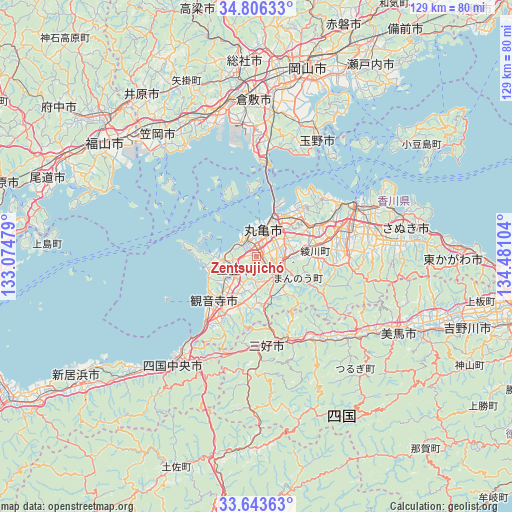
Zentsujichó GPS coordinates[2]
34° 13' 37.164" North, 133° 46' 40.476" East
| Map corner | latitude | longitude |
|---|---|---|
| Upper-left | 34.80633°, | 133.07479° |
| Center: | 34.22699°, | 133.77791° |
| Lower-right: | 33.64363°, | 134.48104° |
| Map W x H: | 129.3×129.3 km | = 80.3×80.3mi |
| max Lat: | 45.40944° ⇑77.1% North |
| Zentsujichó: | 34.22699° |
| min Lat: | ⇓22.9% South 24.34478° |
| min Long | Zentsujichó | max Long |
| 123° | 133.77791° | 145.575° |
| W 23.9%⇐ | ⇒76.1% E |
Elevation
Elevation of Zentsujichó is 32 m = 105 ft, and this is 52.6 m = 173 ft below average elevation for this country.
| Max E: |
1086 m = 3563 ft | 46.8% |
| Avg. | 84.6 m = 278 ft | |
| Zentsujichó | 32 m = 105 ft | |
Min E: |
-2 m = -7 ft | 53.2% |
See also: Japan elevation on elevation.city.
Geographical zone
Zentsujichó is located in North temperate zone (between Tropic of Cancer and the Arctic Circle). Distance of this Northern Tropic circle is 1199.8 km =745.5 mi to South.| Distance of | km | miles | from Zentsujichó |
|---|---|---|---|
| North Pole | 6201.4 | 3853.4 | to North |
| Arctic Circle | 3595.5 | 2234.1 | to North |
| Tropic Cancer | 1199.8 | 745.5 | to South |
| Equator | 3805.7 | 2364.8 | to South |


Nearby cities:
15 places around Zentsujichó: (largest is in red/bold)
• Asakuchi
37.8 km =23.5 mi,  334°
334°
• Ikedachō
22.2 km =13.8 mi,  173°
173°
• Kan’onji
21.1 km =13.1 mi,  214°
214°
• Kan’onjichō
16.4 km =10.2 mi,  227°
227°
• Kawanoechō
29.7 km =18.5 mi,  218°
218°
• Marugame
6.3 km =3.9 mi,  4°
4°
• Mima
38.4 km =23.9 mi,  119°
119°
• Mitoyo
9.7 km =6 mi,  259°
259°
• Miyoshi
34.3 km =21.3 mi, 167°
• Sakaidechō
11.9 km =7.4 mi,  26°
26°
• Shido
37.9 km =23.5 mi,  73°
73°
• Shikokuchūō
35 km =21.7 mi, 217°
• Tadotsu
5.9 km =3.7 mi, 334°
• Takamatsu
27.7 km =17.2 mi,  64°
64°
• Tamano
35.8 km =22.2 mi, 25°
Sources, notices
• [Note1] Compared only with cities in Japan existing in our database
• [Src1] Map data: © OpenStreetMap contributors (CC-BY-SA)
• [Src2] Other city data from geonames.org with taken over terms of usage.
• [Src3] Geographical zone / Annual Mean Temperature by Robert A. Rohde @ Wikipedia
