Tamano geodata
Tamano (Okayama) is a seat of a second-order administrative division; located in Japan in Asia/Tokyo (GMT+9) time zone. With population of 67,786 people, there are 287 cities with bigger population in this country. Compared to other cities in Japan, 71.9% of cities are located further ↑North; 75.1% of cities are located further →East and 76.3% of cities have higher elevation than Tamano. Note1


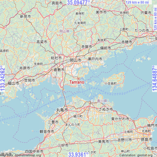
Tamano GPS coordinates[2]
34° 31' 2.82" North, 133° 56' 44.664" East
| Map corner | latitude | longitude |
|---|---|---|
| Upper-left | 35.09477°, | 133.24262° |
| Center: | 34.51745°, | 133.94574° |
| Lower-right: | 33.9361°, | 134.64887° |
| Map W x H: | 128.8×128.8 km | = 80×80mi |
| max Lat: | 45.40944° ⇑71.9% North |
| Tamano: | 34.51745° |
| min Lat: | ⇓28.1% South 24.34478° |
| min Long | Tamano | max Long |
| 123° | 133.94574° | 145.575° |
| W 24.9%⇐ | ⇒75.1% E |
Elevation
Elevation of Tamano is 9 m = 30 ft, and this is 75.6 m = 248 ft below average elevation for this country.
| Max E: |
1086 m = 3563 ft | 76.3% |
| Avg. | 84.6 m = 278 ft | |
| Tamano | 9 m = 30 ft | |
Min E: |
-2 m = -7 ft | 23.7% |
See also: Tamano elevation on elevation.city.
Geographical zone
Tamano is located in North temperate zone (between Tropic of Cancer and the Arctic Circle). Distance of this Northern Tropic circle is 1232.1 km =765.6 mi to South.| Distance of | km | miles | from Tamano |
|---|---|---|---|
| North Pole | 6169.1 | 3833.3 | to North |
| Arctic Circle | 3563.2 | 2214.1 | to North |
| Tropic Cancer | 1232.1 | 765.6 | to South |
| Equator | 3838 | 2384.8 | to South |


Nearby cities:
15 places around Tamano: (largest is in red/bold)
• Akaiwa
33.2 km =20.6 mi,  12°
12°
• Asakuchi
31.5 km =19.6 mi,  273°
273°
• Kamogatachō-kamogata
32.7 km =20.3 mi, 273°
• Kurashiki
18 km =11.2 mi,  294°
294°
• Marugame
30 km =18.6 mi,  209°
209°
• Okayama
14.8 km =9.2 mi,  355°
355°
• Sakaidechō
23.9 km =14.9 mi, 205°
• Sanuki
38.1 km =23.7 mi,  136°
136°
• Setouchi
23.9 km =14.9 mi,  48°
48°
• Shido
30 km =18.6 mi, 135°
• Sōja
25 km =15.5 mi,  314°
314°
• Tadotsu
32.4 km =20.1 mi, 213°
• Takamatsu
22.6 km =14 mi,  154°
154°
• Tonoshō
21 km =13 mi,  101°
101°
• Zentsujichó
35.8 km =22.2 mi, 205°
Sources, notices
• [Note1] Compared only with cities in Japan existing in our database
• [Src1] Map data: © OpenStreetMap contributors (CC-BY-SA)
• [Src2] Other city data from geonames.org with taken over terms of usage.
• [Src3] Geographical zone / Annual Mean Temperature by Robert A. Rohde @ Wikipedia
