Kan’onjichō geodata
Kan’onjichō (Kagawa) is a populated place; located in Japan in Asia/Tokyo (GMT+9) time zone. With population of 44,363 people, there are 411 cities with bigger population in this country. Compared to other cities in Japan, 78.3% of cities are located further ↑North; 76.8% of cities are located further →East and 93.5% of cities have higher elevation than Kan’onjichō. Note1


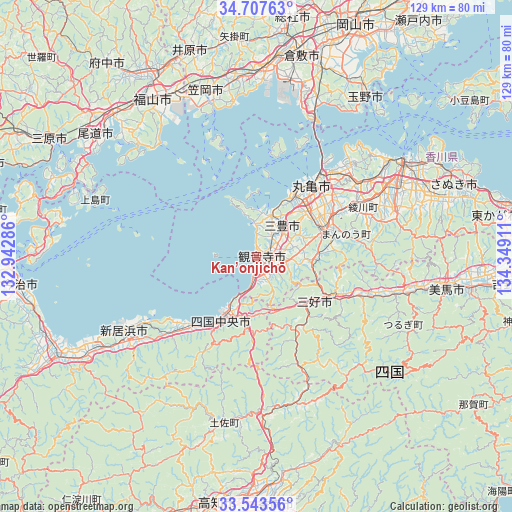
Kan’onjichō GPS coordinates[2]
34° 7' 39.36" North, 133° 38' 45.528" East
| Map corner | latitude | longitude |
|---|---|---|
| Upper-left | 34.70763°, | 132.94286° |
| Center: | 34.1276°, | 133.64598° |
| Lower-right: | 33.54356°, | 134.34911° |
| Map W x H: | 129.4×129.4 km | = 80.4×80.4mi |
| max Lat: | 45.40944° ⇑78.3% North |
| Kan’onjichō: | 34.1276° |
| min Lat: | ⇓21.7% South 24.34478° |
| min Long | Kan’onjichō | max Long |
| 123° | 133.64598° | 145.575° |
| W 23.2%⇐ | ⇒76.8% E |
Elevation
Elevation of Kan’onjichō is 4 m = 13 ft, and this is 80.6 m = 264 ft below average elevation for this country.
| Max E: |
1086 m = 3563 ft | 93.5% |
| Avg. | 84.6 m = 278 ft | |
| Kan’onjichō | 4 m = 13 ft | |
Min E: |
-2 m = -7 ft | 6.5% |
See also: Kan’onjichō elevation on elevation.city.
Geographical zone
Kan’onjichō is located in North temperate zone (between Tropic of Cancer and the Arctic Circle). Distance of this Northern Tropic circle is 1188.7 km =738.6 mi to South.| Distance of | km | miles | from Kan’onjichō |
|---|---|---|---|
| North Pole | 6212.4 | 3860.2 | to North |
| Arctic Circle | 3606.5 | 2241 | to North |
| Tropic Cancer | 1188.7 | 738.6 | to South |
| Equator | 3794.6 | 2357.9 | to South |


Nearby cities:
15 places around Kan’onjichō: (largest is in red/bold)
• Asakuchi
45.5 km =28.3 mi,  355°
355°
• Ikedachō
18.4 km =11.4 mi,  126°
126°
• Innoshima
45.9 km =28.5 mi,  292°
292°
• Kan’onji
6.4 km =4 mi,  177°
177°
• Kasaoka
44 km =27.3 mi,  342°
342°
• Kawanoechō
13.8 km =8.6 mi,  206°
206°
• Marugame
21.4 km =13.3 mi,  36°
36°
• Mitoyo
9.6 km =6 mi,  15°
15°
• Miyoshi
29.7 km =18.5 mi,  139°
139°
• Niihama
36.5 km =22.7 mi,  239°
239°
• Sakaidechō
27.8 km =17.3 mi, 38°
• Shikokuchūō
19.1 km =11.9 mi, 207°
• Tadotsu
19 km =11.8 mi,  30°
30°
• Takamatsu
43.6 km =27.1 mi,  58°
58°
• Zentsujichó
16.4 km =10.2 mi,  47°
47°
Sources, notices
• [Note1] Compared only with cities in Japan existing in our database
• [Src1] Map data: © OpenStreetMap contributors (CC-BY-SA)
• [Src2] Other city data from geonames.org with taken over terms of usage.
• [Src3] Geographical zone / Annual Mean Temperature by Robert A. Rohde @ Wikipedia
