Takasaki geodata
Takasaki (Gunma) is a seat of a second-order administrative division; located in Japan in Asia/Tokyo (GMT+9) time zone. With population of 240,857 people, there are 84 cities with bigger population in this country. Compared to other cities in Japan, 74.6% of cities are located further ↓South; 60.8% of cities are located further ←West and 74.4% of cities have lower elevation than Takasaki. Note1


Takasaki GPS coordinates[2]
36° 19' 59.988" North, 139° 1' 0.012" East
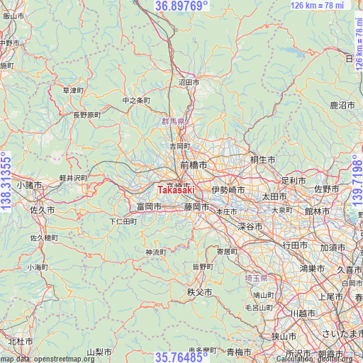
| Map corner | latitude | longitude |
|---|---|---|
| Upper-left | 36.89769°, | 138.31355° |
| Center: | 36.33333°, | 139.01667° |
| Lower-right: | 35.76485°, | 139.7198° |
| Map W x H: | 126×126 km | = 78.3×78.3mi |
| max Lat: | 45.40944° ⇑25.4% North |
| Takasaki: | 36.33333° |
| min Lat: | ⇓74.6% South 24.34478° |
| min Long | Takasaki | max Long |
| 123° | 139.01667° | 145.575° |
| W 60.8%⇐ | ⇒39.2% E |
Elevation
Elevation of Takasaki is 93 m = 305 ft, and this is 8.4 m = 28 ft above average elevation for this country.
| Max E: |
1086 m = 3563 ft | 25.6% |
| Takasaki | 93 m 305 ft | |
| Avg. | 84.6 m = 278 ft | |
Min E: |
-2 m = -7 ft | 74.4% |
See also: Takasaki elevation on elevation.city.
Geographical zone
Takasaki is located in North temperate zone (between Tropic of Cancer and the Arctic Circle). Distance of this Northern Tropic circle is 1434 km =891 mi to South.| Distance of | km | miles | from Takasaki |
|---|---|---|---|
| North Pole | 5967.2 | 3707.8 | to North |
| Arctic Circle | 3361.3 | 2088.6 | to North |
| Tropic Cancer | 1434 | 891 | to South |
| Equator | 4039.9 | 2510.3 | to South |


Nearby cities:
15 places around Takasaki: (largest is in red/bold)
• Annaka
10.8 km =6.7 mi,  268°
268°
• Fujioka
10.9 km =6.8 mi,  152°
152°
• Fukaya
27.9 km =17.3 mi,  128°
128°
• Honjō
18.8 km =11.7 mi,  124°
124°
• Isesaki
16.5 km =10.3 mi,  96°
96°
• Kanekomachi
8.8 km =5.5 mi,  348°
348°
• Kodamachō-kodamaminami
19.5 km =12.1 mi, 147°
• Maebashi
9.5 km =5.9 mi,  38°
38°
• Midori
27 km =16.8 mi,  62°
62°
• Sakai-nakajima
22.2 km =13.8 mi,  109°
109°
• Shibukawa
16.7 km =10.4 mi, 354°
• Tamamura
9.7 km =6 mi, 112°
• Tomioka
13.8 km =8.6 mi,  230°
230°
• Yoshii
9.7 km =6 mi,  197°
197°
• Ōmamachō-ōmama
25.6 km =15.9 mi, 64°
Sources, notices
• [Note1] Compared only with cities in Japan existing in our database
• [Src1] Map data: © OpenStreetMap contributors (CC-BY-SA)
• [Src2] Other city data from geonames.org with taken over terms of usage.
• [Src3] Geographical zone / Annual Mean Temperature by Robert A. Rohde @ Wikipedia
