Oyama geodata
Oyama (Tochigi) is a seat of a second-order administrative division; located in Japan in Asia/Tokyo (GMT+9) time zone. With population of 159,936 people, there are 129 cities with bigger population in this country. Compared to other cities in Japan, 73.4% of cities are located further ↓South; 74.6% of cities are located further ←West and 57.9% of cities have lower elevation than Oyama. Note1


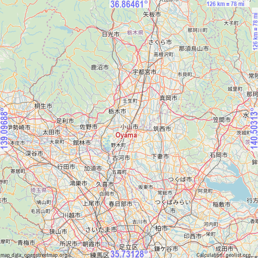
Oyama GPS coordinates[2]
36° 18' 0" North, 139° 48' 0" East
| Map corner | latitude | longitude |
|---|---|---|
| Upper-left | 36.86461°, | 139.09688° |
| Center: | 36.3°, | 139.8° |
| Lower-right: | 35.73128°, | 140.50313° |
| Map W x H: | 126×126 km | = 78.3×78.3mi |
| max Lat: | 45.40944° ⇑26.6% North |
| Oyama: | 36.3° |
| min Lat: | ⇓73.4% South 24.34478° |
| min Long | Oyama | max Long |
| 123° | 139.8° | 145.575° |
| W 74.6%⇐ | ⇒25.4% E |
Elevation
Elevation of Oyama is 41 m = 135 ft, and this is 43.6 m = 143 ft below average elevation for this country.
| Max E: |
1086 m = 3563 ft | 42.1% |
| Avg. | 84.6 m = 278 ft | |
| Oyama | 41 m = 135 ft | |
Min E: |
-2 m = -7 ft | 57.9% |
See also: Oyama elevation on elevation.city.
Geographical zone
Oyama is located in North temperate zone (between Tropic of Cancer and the Arctic Circle). Distance of this Northern Tropic circle is 1430.3 km =888.7 mi to South.| Distance of | km | miles | from Oyama |
|---|---|---|---|
| North Pole | 5970.9 | 3710.1 | to North |
| Arctic Circle | 3365 | 2090.9 | to North |
| Tropic Cancer | 1430.3 | 888.7 | to South |
| Equator | 4036.2 | 2508 | to South |


Nearby cities:
15 places around Oyama: (largest is in red/bold)
• Chikusei
16.4 km =10.2 mi,  83°
83°
• Fujioka
14.5 km =9 mi,  247°
247°
• Kaminokawa
18.1 km =11.2 mi,  35°
35°
• Koga
15 km =9.3 mi,  209°
209°
• Kurihashi
20.6 km =12.8 mi, 205°
• Mibu
13 km =8.1 mi,  0°
0°
• Mooka
24.4 km =15.2 mi,  52°
52°
• Sakai
22.2 km =13.8 mi,  180°
180°
• Sano
19.5 km =12.1 mi,  275°
275°
• Shimo-tsuma
19.8 km =12.3 mi,  130°
130°
• Shimodate
16.4 km =10.2 mi,  90°
90°
• Shimotsuke
13.9 km =8.6 mi,  25°
25°
• Tanuma
20.8 km =12.9 mi,  290°
290°
• Tochigi
11 km =6.8 mi,  327°
327°
• Yūki
7.5 km =4.7 mi, 90°
Sources, notices
• [Note1] Compared only with cities in Japan existing in our database
• [Src1] Map data: © OpenStreetMap contributors (CC-BY-SA)
• [Src2] Other city data from geonames.org with taken over terms of usage.
• [Src3] Geographical zone / Annual Mean Temperature by Robert A. Rohde @ Wikipedia
