Tanuma geodata
Tanuma (Tochigi) is a populated place; located in Japan in Asia/Tokyo (GMT+9) time zone. With population of 28,723 people, there are 561 cities with bigger population in this country. Compared to other cities in Japan, 75.2% of cities are located further ↓South; 71.1% of cities are located further ←West and 68% of cities have lower elevation than Tanuma. Note1


Tanuma GPS coordinates[2]
36° 22' 0.012" North, 139° 34' 59.988" East
| Map corner | latitude | longitude |
|---|---|---|
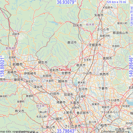
| Upper-left | 36.93079°, | 138.88021° |
| Center: | 36.36667°, | 139.58333° |
| Lower-right: | 35.79843°, | 140.28646° |
| Map W x H: | 125.9×125.9 km | = 78.2×78.2mi |
| max Lat: | 45.40944° ⇑24.8% North |
| Tanuma: | 36.36667° |
| min Lat: | ⇓75.2% South 24.34478° |
| min Long | Tanuma | max Long |
| 123° | 139.58333° | 145.575° |
| W 71.1%⇐ | ⇒28.9% E |
Elevation
Elevation of Tanuma is 66 m = 217 ft, and this is 18.6 m = 61 ft below average elevation for this country.
| Max E: |
1086 m = 3563 ft | 32% |
| Avg. | 84.6 m = 278 ft | |
| Tanuma | 66 m = 217 ft | |
Min E: |
-2 m = -7 ft | 68% |
See also: Japan elevation on elevation.city.
Geographical zone
Tanuma is located in North temperate zone (between Tropic of Cancer and the Arctic Circle). Distance of this Northern Tropic circle is 1437.7 km =893.3 mi to South.| Distance of | km | miles | from Tanuma |
|---|---|---|---|
| North Pole | 5963.5 | 3705.5 | to North |
| Arctic Circle | 3357.6 | 2086.3 | to North |
| Tropic Cancer | 1437.7 | 893.3 | to South |
| Equator | 4043.6 | 2512.6 | to South |


Nearby cities:
15 places around Tanuma: (largest is in red/bold)
• Ashikaga
12.5 km =7.8 mi,  252°
252°
• Fujioka
14.3 km =8.9 mi,  155°
155°
• Gyōda
27.4 km =17 mi,  203°
203°
• Hanyū
22.7 km =14.1 mi,  191°
191°
• Kanuma
24.4 km =15.2 mi,  33°
33°
• Kiryū
22.7 km =14.1 mi,  279°
279°
• Koga
23.6 km =14.7 mi,  149°
149°
• Menuma
24.1 km =15 mi,  228°
228°
• Mibu
20.2 km =12.6 mi,  74°
74°
• Oyama
20.8 km =12.9 mi,  110°
110°
• Sano
5.6 km =3.5 mi,  180°
180°
• Shimotsuke
25.8 km =16 mi,  78°
78°
• Tatebayashi
13.7 km =8.5 mi, 199°
• Tochigi
13.6 km =8.5 mi, 82°
• Ōta
20.8 km =12.9 mi, 249°
Sources, notices
• [Note1] Compared only with cities in Japan existing in our database
• [Src1] Map data: © OpenStreetMap contributors (CC-BY-SA)
• [Src2] Other city data from geonames.org with taken over terms of usage.
• [Src3] Geographical zone / Annual Mean Temperature by Robert A. Rohde @ Wikipedia
