Kurihashi geodata
Kurihashi (Saitama) is a populated place; located in Japan in Asia/Tokyo (GMT+9) time zone. With population of 27,813 people, there are 570 cities with bigger population in this country. Compared to other cities in Japan, 70.2% of cities are located further ↓South; 73.4% of cities are located further ←West and 66.8% of cities have higher elevation than Kurihashi. Note1


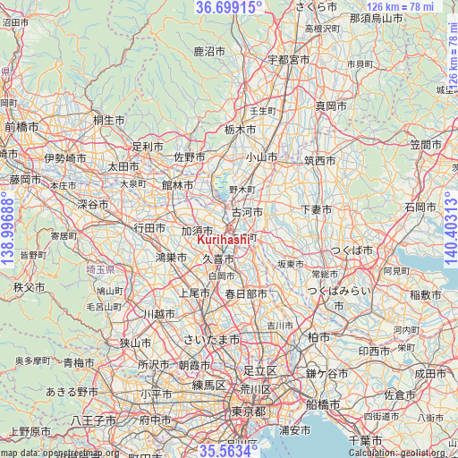
Kurihashi GPS coordinates[2]
36° 7' 59.988" North, 139° 42' 0" East
| Map corner | latitude | longitude |
|---|---|---|
| Upper-left | 36.69915°, | 138.99688° |
| Center: | 36.13333°, | 139.7° |
| Lower-right: | 35.5634°, | 140.40313° |
| Map W x H: | 126.3×126.3 km | = 78.5×78.5mi |
| max Lat: | 45.40944° ⇑29.8% North |
| Kurihashi: | 36.13333° |
| min Lat: | ⇓70.2% South 24.34478° |
| min Long | Kurihashi | max Long |
| 123° | 139.7° | 145.575° |
| W 73.4%⇐ | ⇒26.6% E |
Elevation
Elevation of Kurihashi is 14 m = 46 ft, and this is 70.6 m = 232 ft below average elevation for this country.
| Max E: |
1086 m = 3563 ft | 66.8% |
| Avg. | 84.6 m = 278 ft | |
| Kurihashi | 14 m = 46 ft | |
Min E: |
-2 m = -7 ft | 33.2% |
See also: Japan elevation on elevation.city.
Geographical zone
Kurihashi is located in North temperate zone (between Tropic of Cancer and the Arctic Circle). Distance of this Northern Tropic circle is 1411.7 km =877.2 mi to South.| Distance of | km | miles | from Kurihashi |
|---|---|---|---|
| North Pole | 5989.4 | 3721.6 | to North |
| Arctic Circle | 3383.5 | 2102.4 | to North |
| Tropic Cancer | 1411.7 | 877.2 | to South |
| Equator | 4017.6 | 2496.4 | to South |


Nearby cities:
15 places around Kurihashi: (largest is in red/bold)
• Bandō
16.6 km =10.3 mi,  115°
115°
• Fujioka
13.7 km =8.5 mi,  340°
340°
• Hanyū
15.4 km =9.6 mi,  283°
283°
• Kasukabe
17.3 km =10.7 mi,  165°
165°
• Kazo
9.2 km =5.7 mi,  258°
258°
• Kisai
11.1 km =6.9 mi,  250°
250°
• Kitamoto
18.3 km =11.4 mi,  232°
232°
• Koga
5.8 km =3.6 mi,  15°
15°
• Kukichūō
7.7 km =4.8 mi,  197°
197°
• Kōnosu
18 km =11.2 mi, 246°
• Sakai
9.7 km =6 mi,  112°
112°
• Satte
7.2 km =4.5 mi,  160°
160°
• Shiraoka
13.3 km =8.3 mi, 195°
• Shōbu
11.6 km =7.2 mi, 230°
• Sugito
11.6 km =7.2 mi, 168°
Sources, notices
• [Note1] Compared only with cities in Japan existing in our database
• [Src1] Map data: © OpenStreetMap contributors (CC-BY-SA)
• [Src2] Other city data from geonames.org with taken over terms of usage.
• [Src3] Geographical zone / Annual Mean Temperature by Robert A. Rohde @ Wikipedia
