Sano geodata
Sano (Tochigi) is a seat of a second-order administrative division; located in Japan in Asia/Tokyo (GMT+9) time zone. With population of 82,535 people, there are 242 cities with bigger population in this country. Compared to other cities in Japan, 74.1% of cities are located further ↓South; 71.1% of cities are located further ←West and 55.7% of cities have lower elevation than Sano. Note1


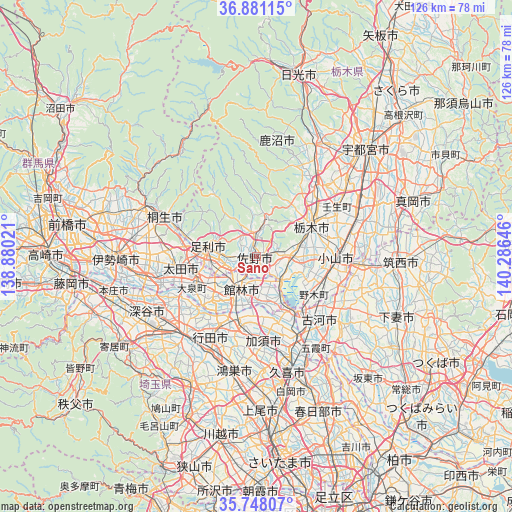
Sano GPS coordinates[2]
36° 19' 0.012" North, 139° 34' 59.988" East
| Map corner | latitude | longitude |
|---|---|---|
| Upper-left | 36.88115°, | 138.88021° |
| Center: | 36.31667°, | 139.58333° |
| Lower-right: | 35.74807°, | 140.28646° |
| Map W x H: | 126×126 km | = 78.3×78.3mi |
| max Lat: | 45.40944° ⇑25.9% North |
| Sano: | 36.31667° |
| min Lat: | ⇓74.1% South 24.34478° |
| min Long | Sano | max Long |
| 123° | 139.58333° | 145.575° |
| W 71.1%⇐ | ⇒28.9% E |
Elevation
Elevation of Sano is 36 m = 118 ft, and this is 48.6 m = 159 ft below average elevation for this country.
| Max E: |
1086 m = 3563 ft | 44.3% |
| Avg. | 84.6 m = 278 ft | |
| Sano | 36 m = 118 ft | |
Min E: |
-2 m = -7 ft | 55.7% |
See also: Sano elevation on elevation.city.
Geographical zone
Sano is located in North temperate zone (between Tropic of Cancer and the Arctic Circle). Distance of this Northern Tropic circle is 1432.1 km =889.9 mi to South.| Distance of | km | miles | from Sano |
|---|---|---|---|
| North Pole | 5969 | 3709 | to North |
| Arctic Circle | 3363.1 | 2089.7 | to North |
| Tropic Cancer | 1432.1 | 889.9 | to South |
| Equator | 4038 | 2509.1 | to South |


Nearby cities:
15 places around Sano: (largest is in red/bold)
• Ashikaga
12.1 km =7.5 mi,  278°
278°
• Fujioka
9.5 km =5.9 mi,  141°
141°
• Gyōda
22.5 km =14 mi,  209°
209°
• Hanyū
17.3 km =10.7 mi,  195°
195°
• Kazo
22.3 km =13.9 mi,  176°
176°
• Kisai
24.1 km =15 mi, 180°
• Koga
19 km =11.8 mi, 141°
• Kurihashi
22.9 km =14.2 mi,  152°
152°
• Menuma
20.9 km =13 mi,  239°
239°
• Mibu
22.4 km =13.9 mi,  60°
60°
• Oyama
19.5 km =12.1 mi,  95°
95°
• Tanuma
5.6 km =3.5 mi,  0°
0°
• Tatebayashi
8.7 km =5.4 mi, 211°
• Tochigi
15.3 km =9.5 mi, 61°
• Ōta
19.5 km =12.1 mi,  264°
264°
Sources, notices
• [Note1] Compared only with cities in Japan existing in our database
• [Src1] Map data: © OpenStreetMap contributors (CC-BY-SA)
• [Src2] Other city data from geonames.org with taken over terms of usage.
• [Src3] Geographical zone / Annual Mean Temperature by Robert A. Rohde @ Wikipedia
