Onoda geodata
Onoda (Yamaguchi) is a populated place; located in Japan in Asia/Tokyo (GMT+9) time zone. With population of 44,295 people, there are 412 cities with bigger population in this country. Compared to other cities in Japan, 80.2% of cities are located further ↑North; 86% of cities are located further →East and 97.9% of cities have higher elevation than Onoda. Note1


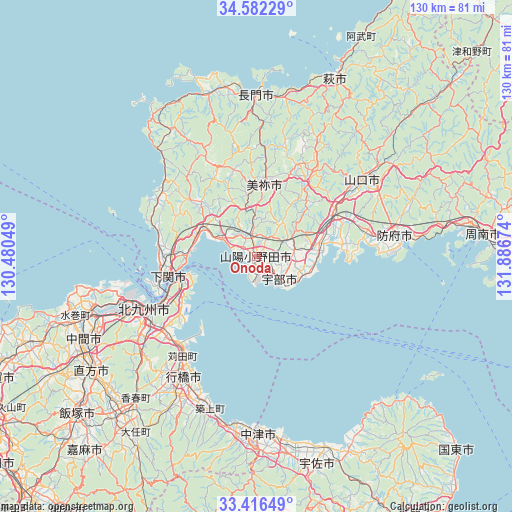
Onoda GPS coordinates[2]
34° 0' 5.004" North, 131° 11' 0.996" East
| Map corner | latitude | longitude |
|---|---|---|
| Upper-left | 34.58229°, | 130.48049° |
| Center: | 34.00139°, | 131.18361° |
| Lower-right: | 33.41649°, | 131.88674° |
| Map W x H: | 129.6×129.6 km | = 80.5×80.5mi |
| max Lat: | 45.40944° ⇑80.2% North |
| Onoda: | 34.00139° |
| min Lat: | ⇓19.8% South 24.34478° |
| min Long | Onoda | max Long |
| 123° | 131.18361° | 145.575° |
| W 14%⇐ | ⇒86% E |
Elevation
Elevation of Onoda is 1 m = 3 ft, and this is 83.6 m = 274 ft below average elevation for this country.
| Max E: |
1086 m = 3563 ft | 97.9% |
| Avg. | 84.6 m = 278 ft | |
| Onoda | 1 m = 3 ft | |
Min E: |
-2 m = -7 ft | 2.1% |
See also: Onoda elevation on elevation.city.
Geographical zone
Onoda is located in North temperate zone (between Tropic of Cancer and the Arctic Circle). Distance of this Northern Tropic circle is 1174.7 km =729.9 mi to South.| Distance of | km | miles | from Onoda |
|---|---|---|---|
| North Pole | 6226.5 | 3869 | to North |
| Arctic Circle | 3620.6 | 2249.7 | to North |
| Tropic Cancer | 1174.7 | 729.9 | to South |
| Equator | 3780.6 | 2349.2 | to South |


Nearby cities:
15 places around Onoda: (largest is in red/bold)
• Buzen
43.6 km =27.1 mi,  186°
186°
• Hōfu
35.7 km =22.2 mi,  81°
81°
• Kanda
30.5 km =19 mi,  217°
217°
• Kitakyushu
35 km =21.7 mi,  241°
241°
• Mine
20.8 km =12.9 mi,  8°
8°
• Nagato
42.5 km =26.4 mi,  2°
2°
• Ogōri-shimogō
22.8 km =14.2 mi,  61°
61°
• Sanyōonoda
4.1 km =2.5 mi,  328°
328°
• Shiida
40.4 km =25.1 mi,  196°
196°
• Shimonoseki
22.3 km =13.9 mi,  255°
255°
• Shimonoseki
25 km =15.5 mi,  317°
317°
• Tsuiki
38.9 km =24.2 mi, 200°
• Ube
9 km =5.6 mi,  136°
136°
• Yamaguchi
33 km =20.5 mi,  52°
52°
• Yukuhashi
35.5 km =22.1 mi,  211°
211°
Sources, notices
• [Note1] Compared only with cities in Japan existing in our database
• [Src1] Map data: © OpenStreetMap contributors (CC-BY-SA)
• [Src2] Other city data from geonames.org with taken over terms of usage.
• [Src3] Geographical zone / Annual Mean Temperature by Robert A. Rohde @ Wikipedia
