Mine geodata
Mine (Yamaguchi) is a seat of a second-order administrative division; located in Japan in Asia/Tokyo (GMT+9) time zone. In our database, there are 767 cities with bigger population. Compared to other cities in Japan, 77.9% of cities are located further ↑North; 85.7% of cities are located further →East and 79.9% of cities have lower elevation than Mine. Note1


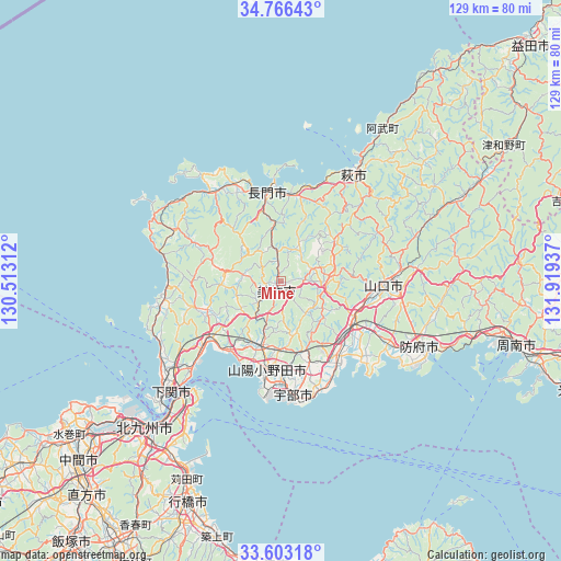
Mine GPS coordinates[2]
34° 11' 12.516" North, 131° 12' 58.464" East
| Map corner | latitude | longitude |
|---|---|---|
| Upper-left | 34.76643°, | 130.51312° |
| Center: | 34.18681°, | 131.21624° |
| Lower-right: | 33.60318°, | 131.91937° |
| Map W x H: | 129.3×129.3 km | = 80.3×80.3mi |
| max Lat: | 45.40944° ⇑77.9% North |
| Mine: | 34.18681° |
| min Lat: | ⇓22.1% South 24.34478° |
| min Long | Mine | max Long |
| 123° | 131.21624° | 145.575° |
| W 14.3%⇐ | ⇒85.7% E |
Elevation
Elevation of Mine is 123 m = 404 ft, and this is 38.4 m = 126 ft above average elevation for this country.
| Max E: |
1086 m = 3563 ft | 20.1% |
| Mine | 123 m 404 ft | |
| Avg. | 84.6 m = 278 ft | |
Min E: |
-2 m = -7 ft | 79.9% |
See also: Japan elevation on elevation.city.
Geographical zone
Mine is located in North temperate zone (between Tropic of Cancer and the Arctic Circle). Distance of this Northern Tropic circle is 1195.3 km =742.7 mi to South.| Distance of | km | miles | from Mine |
|---|---|---|---|
| North Pole | 6205.8 | 3856.1 | to North |
| Arctic Circle | 3600 | 2236.9 | to North |
| Tropic Cancer | 1195.3 | 742.7 | to South |
| Equator | 3801.2 | 2362 | to South |


Nearby cities:
15 places around Mine: (largest is in red/bold)
• Hagi
30 km =18.6 mi,  37°
37°
• Hōfu
35.7 km =22.2 mi,  115°
115°
• Kanda
49.7 km =30.9 mi,  205°
205°
• Kitakyushu
50.2 km =31.2 mi,  222°
222°
• Nagato
21.9 km =13.6 mi,  356°
356°
• Ogōri-shimogō
19.5 km =12.1 mi, 119°
• Onoda
20.8 km =12.9 mi,  188°
188°
• Sanyōonoda
17.9 km =11.1 mi,  196°
196°
• Shimonoseki
20 km =12.4 mi,  263°
263°
• Shimonoseki
36 km =22.4 mi, 222°
• Shūnan
57.3 km =35.6 mi,  101°
101°
• Tokuyama
57.3 km =35.6 mi,  105°
105°
• Ube
27.3 km =17 mi,  173°
173°
• Yamaguchi
23 km =14.3 mi,  90°
90°
• Yukuhashi
55.3 km =34.4 mi, 202°
Sources, notices
• [Note1] Compared only with cities in Japan existing in our database
• [Src1] Map data: © OpenStreetMap contributors (CC-BY-SA)
• [Src2] Other city data from geonames.org with taken over terms of usage.
• [Src3] Geographical zone / Annual Mean Temperature by Robert A. Rohde @ Wikipedia
