Ogōri-shimogō geodata
Ogōri-shimogō (Yamaguchi) is a populated place; located in Japan in Asia/Tokyo (GMT+9) time zone. With population of 23,516 people, there are 630 cities with bigger population in this country. Compared to other cities in Japan, 78.4% of cities are located further ↑North; 85% of cities are located further →East and 93.5% of cities have higher elevation than Ogōri-shimogō. Note1


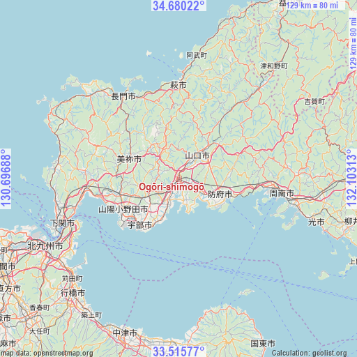
Ogōri-shimogō GPS coordinates[2]
34° 6' 0" North, 131° 24' 0" East
| Map corner | latitude | longitude |
|---|---|---|
| Upper-left | 34.68022°, | 130.69688° |
| Center: | 34.1°, | 131.4° |
| Lower-right: | 33.51577°, | 132.10313° |
| Map W x H: | 129.5×129.5 km | = 80.5×80.5mi |
| max Lat: | 45.40944° ⇑78.4% North |
| Ogōri-shimogō: | 34.1° |
| min Lat: | ⇓21.6% South 24.34478° |
| min Long | Ogōri-shimogō | max Long |
| 123° | 131.4° | 145.575° |
| W 15%⇐ | ⇒85% E |
Elevation
Elevation of Ogōri-shimogō is 4 m = 13 ft, and this is 80.6 m = 264 ft below average elevation for this country.
| Max E: |
1086 m = 3563 ft | 93.5% |
| Avg. | 84.6 m = 278 ft | |
| Ogōri-shimogō | 4 m = 13 ft | |
Min E: |
-2 m = -7 ft | 6.5% |
See also: Japan elevation on elevation.city.
Geographical zone
Ogōri-shimogō is located in North temperate zone (between Tropic of Cancer and the Arctic Circle). Distance of this Northern Tropic circle is 1185.6 km =736.7 mi to South.| Distance of | km | miles | from Ogōri-shimogō |
|---|---|---|---|
| North Pole | 6215.5 | 3862.1 | to North |
| Arctic Circle | 3609.6 | 2242.9 | to North |
| Tropic Cancer | 1185.6 | 736.7 | to South |
| Equator | 3791.6 | 2356 | to South |


Nearby cities:
15 places around Ogōri-shimogō: (largest is in red/bold)
• Hagi
33.4 km =20.8 mi,  2°
2°
• Hikari
53.2 km =33.1 mi,  107°
107°
• Hōfu
16.3 km =10.1 mi, 109°
• Kanda
52.1 km =32.4 mi,  227°
227°
• Kudamatsu
44.4 km =27.6 mi,  104°
104°
• Mine
19.5 km =12.1 mi,  299°
299°
• Nagato
36.5 km =22.7 mi,  329°
329°
• Onoda
22.8 km =14.2 mi,  241°
241°
• Sanyōonoda
23.3 km =14.5 mi,  251°
251°
• Shimonoseki
37.6 km =23.4 mi,  281°
281°
• Shimonoseki
44.7 km =27.8 mi, 248°
• Shūnan
39.3 km =24.4 mi,  93°
93°
• Tokuyama
38.8 km =24.1 mi, 98°
• Ube
22.2 km =13.8 mi,  218°
218°
• Yamaguchi
11.1 km =6.9 mi,  33°
33°
Sources, notices
• [Note1] Compared only with cities in Japan existing in our database
• [Src1] Map data: © OpenStreetMap contributors (CC-BY-SA)
• [Src2] Other city data from geonames.org with taken over terms of usage.
• [Src3] Geographical zone / Annual Mean Temperature by Robert A. Rohde @ Wikipedia
