Yamaguchi geodata
Yamaguchi is a seat of a first-order administrative division; located in Japan in Asia/Tokyo (GMT+9) time zone. With population of 145,515 people, there are 143 cities with bigger population in this country. Compared to other cities in Japan, 78% of cities are located further ↑North; 84.4% of cities are located further →East and 83.6% of cities have lower elevation than Yamaguchi. Note1


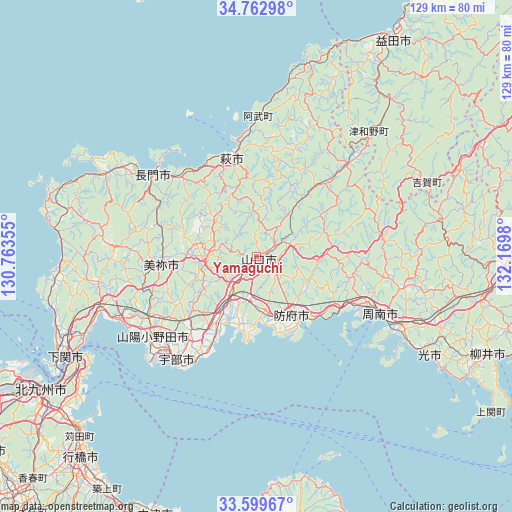
Yamaguchi GPS coordinates[2]
34° 10' 59.988" North, 131° 28' 0.012" East
| Map corner | latitude | longitude |
|---|---|---|
| Upper-left | 34.76298°, | 130.76355° |
| Center: | 34.18333°, | 131.46667° |
| Lower-right: | 33.59967°, | 132.1698° |
| Map W x H: | 129.3×129.3 km | = 80.3×80.3mi |
| max Lat: | 45.40944° ⇑78% North |
| Yamaguchi: | 34.18333° |
| min Lat: | ⇓22% South 24.34478° |
| min Long | Yamaguchi | max Long |
| 123° | 131.46667° | 145.575° |
| W 15.6%⇐ | ⇒84.4% E |
Elevation
Elevation of Yamaguchi is 157 m = 515 ft, and this is 72.4 m = 238 ft above average elevation for this country.
| Max E: |
1086 m = 3563 ft | 16.4% |
| Yamaguchi | 157 m 515 ft | |
| Avg. | 84.6 m = 278 ft | |
Min E: |
-2 m = -7 ft | 83.6% |
See also: Yamaguchi elevation on elevation.city.
Geographical zone
Yamaguchi is located in North temperate zone (between Tropic of Cancer and the Arctic Circle). Distance of this Northern Tropic circle is 1194.9 km =742.5 mi to South.| Distance of | km | miles | from Yamaguchi |
|---|---|---|---|
| North Pole | 6206.2 | 3856.4 | to North |
| Arctic Circle | 3600.3 | 2237.1 | to North |
| Tropic Cancer | 1194.9 | 742.5 | to South |
| Equator | 3800.8 | 2361.7 | to South |


Nearby cities:
15 places around Yamaguchi: (largest is in red/bold)
• Hagi
24.5 km =15.2 mi,  349°
349°
• Hikari
51.2 km =31.8 mi,  119°
119°
• Hōfu
17.5 km =10.9 mi,  148°
148°
• Kanda
63 km =39.1 mi,  225°
225°
• Kudamatsu
42.1 km =26.2 mi, 118°
• Mine
23 km =14.3 mi,  270°
270°
• Nagato
33.1 km =20.6 mi,  312°
312°
• Ogōri-shimogō
11.1 km =6.9 mi,  213°
213°
• Onoda
33 km =20.5 mi, 232°
• Sanyōonoda
32.8 km =20.4 mi,  239°
239°
• Shimonoseki
43 km =26.7 mi, 267°
• Shimonoseki
54.2 km =33.7 mi, 241°
• Shūnan
35 km =21.7 mi,  109°
109°
• Tokuyama
35.5 km =22.1 mi, 114°
• Ube
33.3 km =20.7 mi,  216°
216°
Sources, notices
• [Note1] Compared only with cities in Japan existing in our database
• [Src1] Map data: © OpenStreetMap contributors (CC-BY-SA)
• [Src2] Other city data from geonames.org with taken over terms of usage.
• [Src3] Geographical zone / Annual Mean Temperature by Robert A. Rohde @ Wikipedia
