Nishinoomote geodata
Nishinoomote (Kagoshima) is a seat of a second-order administrative division; located in Japan in Asia/Tokyo (GMT+9) time zone. With population of 17,832 people, there are 722 cities with bigger population in this country. Compared to other cities in Japan, 97.5% of cities are located further ↑North; 87.2% of cities are located further →East and 56.8% of cities have lower elevation than Nishinoomote. Note1


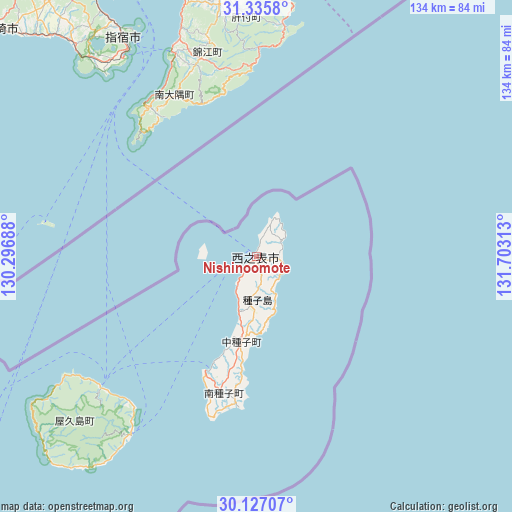
Nishinoomote GPS coordinates[2]
30° 43' 59.988" North, 131° 0' 0" East
| Map corner | latitude | longitude |
|---|---|---|
| Upper-left | 31.3358°, | 130.29688° |
| Center: | 30.73333°, | 131° |
| Lower-right: | 30.12707°, | 131.70313° |
| Map W x H: | 134.4×134.4 km | = 83.5×83.5mi |
| max Lat: | 45.40944° ⇑97.5% North |
| Nishinoomote: | 30.73333° |
| min Lat: | ⇓2.5% South 24.34478° |
| min Long | Nishinoomote | max Long |
| 123° | 131° | 145.575° |
| W 12.8%⇐ | ⇒87.2% E |
Elevation
Elevation of Nishinoomote is 38 m = 125 ft, and this is 46.6 m = 153 ft below average elevation for this country.
| Max E: |
1086 m = 3563 ft | 43.2% |
| Avg. | 84.6 m = 278 ft | |
| Nishinoomote | 38 m = 125 ft | |
Min E: |
-2 m = -7 ft | 56.8% |
See also: Japan elevation on elevation.city.
Geographical zone
Nishinoomote is located in North temperate zone (between Tropic of Cancer and the Arctic Circle). Distance of this Northern Tropic circle is 811.3 km =504.1 mi to South.| Distance of | km | miles | from Nishinoomote |
|---|---|---|---|
| North Pole | 6589.8 | 4094.7 | to North |
| Arctic Circle | 3983.9 | 2475.5 | to North |
| Tropic Cancer | 811.3 | 504.1 | to South |
| Equator | 3417.2 | 2123.3 | to South |


Nearby cities:
15 places around Nishinoomote: (largest is in red/bold)
• Ibusuki
64.8 km =40.3 mi,  329°
329°
• Kanoya
73.7 km =45.8 mi,  348°
348°
• Kaseda-shirakame
100 km =62.1 mi,  319°
319°
• Koseda
51 km =31.7 mi,  221°
221°
• Koshima
71.1 km =44.2 mi, 218°
• Kurio
75.4 km =46.9 mi,  227°
227°
• Kushima
86.8 km =53.9 mi,  15°
15°
• Makurazaki
88.1 km =54.7 mi,  312°
312°
• Minamikyushu
85.7 km =53.3 mi, 322°
• Minamisatsuma
99.9 km =62.1 mi, 316°
• Miyanoura
53.3 km =33.1 mi, 230°
• Nagata
66.6 km =41.4 mi,  235°
235°
• Shibushi
83.1 km =51.6 mi,  6°
6°
• Tarumizu
88.1 km =54.7 mi,  341°
341°
• Yudomari
74.6 km =46.4 mi, 221°
Sources, notices
• [Note1] Compared only with cities in Japan existing in our database
• [Src1] Map data: © OpenStreetMap contributors (CC-BY-SA)
• [Src2] Other city data from geonames.org with taken over terms of usage.
• [Src3] Geographical zone / Annual Mean Temperature by Robert A. Rohde @ Wikipedia
