Miyanoura geodata
Miyanoura (Kagoshima) is a populated place; located in Japan in Asia/Tokyo (GMT+9) time zone. With population of 6,544 people, there are 750 cities with bigger population in this country. Compared to other cities in Japan, 97.6% of cities are located further ↑North; 91.5% of cities are located further →East and 79% of cities have higher elevation than Miyanoura. Note1


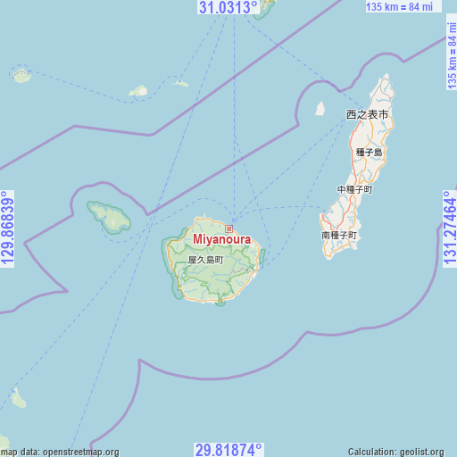
Miyanoura GPS coordinates[2]
30° 25' 36.84" North, 130° 34' 17.436" East
| Map corner | latitude | longitude |
|---|---|---|
| Upper-left | 31.0313°, | 129.86839° |
| Center: | 30.4269°, | 130.57151° |
| Lower-right: | 29.81874°, | 131.27464° |
| Map W x H: | 134.8×134.8 km | = 83.8×83.8mi |
| max Lat: | 45.40944° ⇑97.6% North |
| Miyanoura: | 30.4269° |
| min Lat: | ⇓2.4% South 24.34478° |
| min Long | Miyanoura | max Long |
| 123° | 130.57151° | 145.575° |
| W 8.5%⇐ | ⇒91.5% E |
Elevation
Elevation of Miyanoura is 8 m = 26 ft, and this is 76.6 m = 251 ft below average elevation for this country.
| Max E: |
1086 m = 3563 ft | 79% |
| Avg. | 84.6 m = 278 ft | |
| Miyanoura | 8 m = 26 ft | |
Min E: |
-2 m = -7 ft | 21% |
See also: Japan elevation on elevation.city.
Geographical zone
Miyanoura is located in North temperate zone (between Tropic of Cancer and the Arctic Circle). Distance of this Northern Tropic circle is 777.2 km =482.9 mi to South.| Distance of | km | miles | from Miyanoura |
|---|---|---|---|
| North Pole | 6623.9 | 4115.9 | to North |
| Arctic Circle | 4018 | 2496.7 | to North |
| Tropic Cancer | 777.2 | 482.9 | to South |
| Equator | 3383.2 | 2102.2 | to South |


Nearby cities:
15 places around Miyanoura: (largest is in red/bold)
• Ibusuki
90 km =55.9 mi,  4°
4°
• Kagoshima
126.7 km =78.7 mi,  359°
359°
• Kanoya
109.6 km =68.1 mi,  14°
14°
• Kaseda-shirakame
112.7 km =70 mi,  347°
347°
• Koseda
8.6 km =5.3 mi,  120°
120°
• Koshima
21.7 km =13.5 mi,  189°
189°
• Kurio
22.4 km =13.9 mi,  219°
219°
• Makurazaki
96.5 km =60 mi, 345°
• Minamikyushu
102.9 km =63.9 mi, 353°
• Minamisatsuma
110.6 km =68.7 mi, 345°
• Nagata
14.4 km =8.9 mi,  255°
255°
• Nishinoomote
53.3 km =33.1 mi,  50°
50°
• Shibushi
127.1 km =79 mi,  23°
23°
• Tarumizu
118.1 km =73.4 mi, 5°
• Yudomari
23.1 km =14.4 mi,  202°
202°
Sources, notices
• [Note1] Compared only with cities in Japan existing in our database
• [Src1] Map data: © OpenStreetMap contributors (CC-BY-SA)
• [Src2] Other city data from geonames.org with taken over terms of usage.
• [Src3] Geographical zone / Annual Mean Temperature by Robert A. Rohde @ Wikipedia
