Kurio geodata
Kurio (Kagoshima) is a populated place; located in Japan in Asia/Tokyo (GMT+9) time zone. With population of 1,803 people, there are 761 cities with bigger population in this country. Compared to other cities in Japan, 97.9% of cities are located further ↑North; 93.8% of cities are located further →East and 93.5% of cities have higher elevation than Kurio. Note1


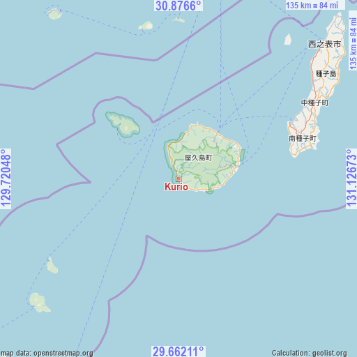
Kurio GPS coordinates[2]
30° 16' 16.428" North, 130° 25' 24.96" East
| Map corner | latitude | longitude |
|---|---|---|
| Upper-left | 30.8766°, | 129.72048° |
| Center: | 30.27123°, | 130.4236° |
| Lower-right: | 29.66211°, | 131.12673° |
| Map W x H: | 135×135 km | = 83.9×83.9mi |
| max Lat: | 45.40944° ⇑97.9% North |
| Kurio: | 30.27123° |
| min Lat: | ⇓2.1% South 24.34478° |
| min Long | Kurio | max Long |
| 123° | 130.4236° | 145.575° |
| W 6.2%⇐ | ⇒93.8% E |
Elevation
Elevation of Kurio is 4 m = 13 ft, and this is 80.6 m = 264 ft below average elevation for this country.
| Max E: |
1086 m = 3563 ft | 93.5% |
| Avg. | 84.6 m = 278 ft | |
| Kurio | 4 m = 13 ft | |
Min E: |
-2 m = -7 ft | 6.5% |
See also: Japan elevation on elevation.city.
Geographical zone
Kurio is located in North temperate zone (between Tropic of Cancer and the Arctic Circle). Distance of this Northern Tropic circle is 759.9 km =472.2 mi to South.| Distance of | km | miles | from Kurio |
|---|---|---|---|
| North Pole | 6641.2 | 4126.6 | to North |
| Arctic Circle | 4035.3 | 2507.4 | to North |
| Tropic Cancer | 759.9 | 472.2 | to South |
| Equator | 3365.8 | 2091.4 | to South |


Nearby cities:
15 places around Kurio: (largest is in red/bold)
• Hioki
146.1 km =90.8 mi,  357°
357°
• Ibusuki
109.1 km =67.8 mi,  11°
11°
• Kagoshima
144.5 km =89.8 mi,  4°
4°
• Kanoya
130.2 km =80.9 mi,  18°
18°
• Kaseda-shirakame
127.8 km =79.4 mi, 355°
• Koseda
25.2 km =15.7 mi,  59°
59°
• Koshima
11.5 km =7.1 mi,  110°
110°
• Makurazaki
111.2 km =69.1 mi,  354°
354°
• Minamikyushu
119.6 km =74.3 mi, 1°
• Minamisatsuma
125.1 km =77.7 mi, 353°
• Miyanoura
22.4 km =13.9 mi,  39°
39°
• Nagata
13.8 km =8.6 mi, 0°
• Nishinoomote
75.4 km =46.9 mi,  47°
47°
• Tarumizu
137.3 km =85.3 mi, 11°
• Yudomari
6.7 km =4.2 mi,  127°
127°
Sources, notices
• [Note1] Compared only with cities in Japan existing in our database
• [Src1] Map data: © OpenStreetMap contributors (CC-BY-SA)
• [Src2] Other city data from geonames.org with taken over terms of usage.
• [Src3] Geographical zone / Annual Mean Temperature by Robert A. Rohde @ Wikipedia
