Shibushi geodata
Shibushi (Kagoshima) is a seat of a second-order administrative division; located in Japan in Asia/Tokyo (GMT+9) time zone. With population of 18,349 people, there are 718 cities with bigger population in this country. Compared to other cities in Japan, 96.9% of cities are located further ↑North; 86.5% of cities are located further →East and 71.1% of cities have higher elevation than Shibushi. Note1


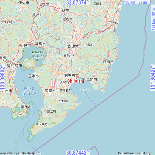
Shibushi GPS coordinates[2]
31° 28' 33.6" North, 131° 6' 4.104" East
| Map corner | latitude | longitude |
|---|---|---|
| Upper-left | 32.07374°, | 130.39802° |
| Center: | 31.476°, | 131.10114° |
| Lower-right: | 30.87442°, | 131.80427° |
| Map W x H: | 133.4×133.4 km | = 82.9×82.9mi |
| max Lat: | 45.40944° ⇑96.9% North |
| Shibushi: | 31.476° |
| min Lat: | ⇓3.1% South 24.34478° |
| min Long | Shibushi | max Long |
| 123° | 131.10114° | 145.575° |
| W 13.5%⇐ | ⇒86.5% E |
Elevation
Elevation of Shibushi is 11 m = 36 ft, and this is 73.6 m = 241 ft below average elevation for this country.
| Max E: |
1086 m = 3563 ft | 71.1% |
| Avg. | 84.6 m = 278 ft | |
| Shibushi | 11 m = 36 ft | |
Min E: |
-2 m = -7 ft | 28.9% |
See also: Japan elevation on elevation.city.
Geographical zone
Shibushi is located in North temperate zone (between Tropic of Cancer and the Arctic Circle). Distance of this Northern Tropic circle is 893.9 km =555.4 mi to South.| Distance of | km | miles | from Shibushi |
|---|---|---|---|
| North Pole | 6507.3 | 4043.4 | to North |
| Arctic Circle | 3901.4 | 2424.2 | to North |
| Tropic Cancer | 893.9 | 555.4 | to South |
| Equator | 3499.8 | 2174.7 | to South |


Nearby cities:
15 places around Shibushi: (largest is in red/bold)
• Hamanoichi
43.9 km =27.3 mi,  307°
307°
• Ibusuki
50.6 km =31.4 mi,  237°
237°
• Kagoshima
53.2 km =33.1 mi,  280°
280°
• Kajiki
50.1 km =31.1 mi,  304°
304°
• Kanoya
26 km =16.2 mi,  246°
246°
• Kirishima
43.5 km =27 mi, 312°
• Kobayashi
57.5 km =35.7 mi,  348°
348°
• Kokubu-matsuki
42.7 km =26.5 mi, 312°
• Kushima
13.4 km =8.3 mi,  85°
85°
• Miyakonojō
28.8 km =17.9 mi, 353°
• Miyazaki
57.4 km =35.7 mi,  31°
31°
• Nichinan
28.7 km =17.8 mi,  61°
61°
• Soo
21.6 km =13.4 mi,  331°
331°
• Sueyoshichō-ninokata
20.9 km =13 mi,  337°
337°
• Tarumizu
38 km =23.6 mi,  271°
271°
Sources, notices
• [Note1] Compared only with cities in Japan existing in our database
• [Src1] Map data: © OpenStreetMap contributors (CC-BY-SA)
• [Src2] Other city data from geonames.org with taken over terms of usage.
• [Src3] Geographical zone / Annual Mean Temperature by Robert A. Rohde @ Wikipedia
