Iiyama geodata
Iiyama (Nagano) is a seat of a second-order administrative division; located in Japan in Asia/Tokyo (GMT+9) time zone. With population of 25,281 people, there are 608 cities with bigger population in this country. Compared to other cities in Japan, 81.3% of cities are located further ↓South; 55.8% of cities are located further ←West and 93.3% of cities have lower elevation than Iiyama. Note1


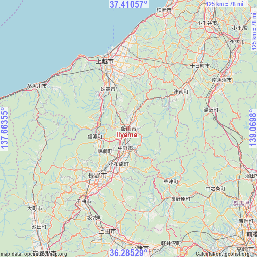
Iiyama GPS coordinates[2]
36° 51' 0" North, 138° 22' 0.012" East
| Map corner | latitude | longitude |
|---|---|---|
| Upper-left | 37.41057°, | 137.66355° |
| Center: | 36.85°, | 138.36667° |
| Lower-right: | 36.28529°, | 139.0698° |
| Map W x H: | 125.1×125.1 km | = 77.7×77.7mi |
| max Lat: | 45.40944° ⇑18.7% North |
| Iiyama: | 36.85° |
| min Lat: | ⇓81.3% South 24.34478° |
| min Long | Iiyama | max Long |
| 123° | 138.36667° | 145.575° |
| W 55.8%⇐ | ⇒44.2% E |
Elevation
Elevation of Iiyama is 311 m = 1020 ft, and this is 226.4 m = 743 ft above average elevation for this country.
| Max E: |
1086 m = 3563 ft | 6.7% |
| Iiyama | 311 m 1020 ft | |
| Avg. | 84.6 m = 278 ft | |
Min E: |
-2 m = -7 ft | 93.3% |
See also: Japan elevation on elevation.city.
Geographical zone
Iiyama is located in North temperate zone (between Tropic of Cancer and the Arctic Circle). Distance of this Northern Tropic circle is 1491.4 km =926.7 mi to South.| Distance of | km | miles | from Iiyama |
|---|---|---|---|
| North Pole | 5909.7 | 3672.1 | to North |
| Arctic Circle | 3303.8 | 2052.9 | to North |
| Tropic Cancer | 1491.4 | 926.7 | to South |
| Equator | 4097.3 | 2545.9 | to South |


Nearby cities:
15 places around Iiyama: (largest is in red/bold)
• Arai
20.9 km =13 mi,  323°
323°
• Chikuma
43.6 km =27.1 mi,  214°
214°
• Hakuba
48 km =29.8 mi,  249°
249°
• Itoigawa
50.2 km =31.2 mi,  293°
293°
• Jōetsu
35.1 km =21.8 mi,  340°
340°
• Minamiuonuma
52 km =32.3 mi,  60°
60°
• Muikamachi
51.8 km =32.2 mi, 62°
• Myoko
20.1 km =12.5 mi, 335°
• Nagano
27.6 km =17.1 mi,  216°
216°
• Nakano
11.1 km =6.9 mi,  180°
180°
• Nakanojōmachi
51.4 km =31.9 mi,  124°
124°
• Shiozawa
47.6 km =29.6 mi, 64°
• Suzaka
22.7 km =14.1 mi,  191°
191°
• Tōkamachi
47.5 km =29.5 mi,  48°
48°
• Ueda
50.3 km =31.3 mi, 188°
Sources, notices
• [Note1] Compared only with cities in Japan existing in our database
• [Src1] Map data: © OpenStreetMap contributors (CC-BY-SA)
• [Src2] Other city data from geonames.org with taken over terms of usage.
• [Src3] Geographical zone / Annual Mean Temperature by Robert A. Rohde @ Wikipedia
