Mikuni geodata
Mikuni (Fukui) is a populated place; located in Japan in Asia/Tokyo (GMT+9) time zone. With population of 23,480 people, there are 632 cities with bigger population in this country. Compared to other cities in Japan, 71.7% of cities are located further ↓South; 60.6% of cities are located further →East and 73.6% of cities have higher elevation than Mikuni. Note1


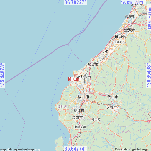
Mikuni GPS coordinates[2]
36° 13' 1.416" North, 136° 9' 6.66" East
| Map corner | latitude | longitude |
|---|---|---|
| Upper-left | 36.78227°, | 135.44873° |
| Center: | 36.21706°, | 136.15185° |
| Lower-right: | 35.64774°, | 136.85498° |
| Map W x H: | 126.1×126.1 km | = 78.4×78.4mi |
| max Lat: | 45.40944° ⇑28.3% North |
| Mikuni: | 36.21706° |
| min Lat: | ⇓71.7% South 24.34478° |
| min Long | Mikuni | max Long |
| 123° | 136.15185° | 145.575° |
| W 39.4%⇐ | ⇒60.6% E |
Elevation
Elevation of Mikuni is 10 m = 33 ft, and this is 74.6 m = 245 ft below average elevation for this country.
| Max E: |
1086 m = 3563 ft | 73.6% |
| Avg. | 84.6 m = 278 ft | |
| Mikuni | 10 m = 33 ft | |
Min E: |
-2 m = -7 ft | 26.4% |
See also: Japan elevation on elevation.city.
Geographical zone
Mikuni is located in North temperate zone (between Tropic of Cancer and the Arctic Circle). Distance of this Northern Tropic circle is 1421 km =883 mi to South.| Distance of | km | miles | from Mikuni |
|---|---|---|---|
| North Pole | 5980.1 | 3715.9 | to North |
| Arctic Circle | 3374.2 | 2096.6 | to North |
| Tropic Cancer | 1421 | 883 | to South |
| Equator | 4027 | 2502.3 | to South |


Nearby cities:
15 places around Mikuni: (largest is in red/bold)
• Asahi
27.3 km =17 mi,  185°
185°
• Awara
3.7 km =2.3 mi,  79°
79°
• Echizen
36.9 km =22.9 mi,  177°
177°
• Fukui-shi
18.1 km =11.2 mi,  159°
159°
• Hakusan
48.8 km =30.3 mi,  52°
52°
• Kaga
18.7 km =11.6 mi,  60°
60°
• Katsuyama
35.8 km =22.2 mi,  118°
118°
• Komatsu
33.8 km =21 mi, 52°
• Maruoka
12.8 km =8 mi, 123°
• Matsutō
49.9 km =31 mi, 48°
• Nomi
42.4 km =26.3 mi, 56°
• Ono
40 km =24.9 mi,  131°
131°
• Sabae
30.2 km =18.8 mi,  174°
174°
• Sakai
8.6 km =5.3 mi,  153°
153°
• Takefu
34.8 km =21.6 mi, 177°
Sources, notices
• [Note1] Compared only with cities in Japan existing in our database
• [Src1] Map data: © OpenStreetMap contributors (CC-BY-SA)
• [Src2] Other city data from geonames.org with taken over terms of usage.
• [Src3] Geographical zone / Annual Mean Temperature by Robert A. Rohde @ Wikipedia
