Sakai geodata
Sakai (Fukui) is a seat of a second-order administrative division; located in Japan in Asia/Tokyo (GMT+9) time zone. In our database, there are 767 cities with bigger population. Compared to other cities in Japan, 70.6% of cities are located further ↓South; 59.9% of cities are located further →East and 89.6% of cities have higher elevation than Sakai. Note1


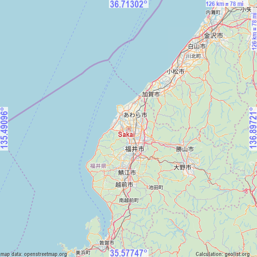
Sakai GPS coordinates[2]
36° 8' 50.28" North, 136° 11' 38.688" East
| Map corner | latitude | longitude |
|---|---|---|
| Upper-left | 36.71302°, | 135.49096° |
| Center: | 36.1473°, | 136.19408° |
| Lower-right: | 35.57747°, | 136.89721° |
| Map W x H: | 126.3×126.3 km | = 78.5×78.5mi |
| max Lat: | 45.40944° ⇑29.4% North |
| Sakai: | 36.1473° |
| min Lat: | ⇓70.6% South 24.34478° |
| min Long | Sakai | max Long |
| 123° | 136.19408° | 145.575° |
| W 40.1%⇐ | ⇒59.9% E |
Elevation
Elevation of Sakai is 5 m = 16 ft, and this is 79.6 m = 261 ft below average elevation for this country.
| Max E: |
1086 m = 3563 ft | 89.6% |
| Avg. | 84.6 m = 278 ft | |
| Sakai | 5 m = 16 ft | |
Min E: |
-2 m = -7 ft | 10.4% |
See also: Japan elevation on elevation.city.
Geographical zone
Sakai is located in North temperate zone (between Tropic of Cancer and the Arctic Circle). Distance of this Northern Tropic circle is 1413.3 km =878.2 mi to South.| Distance of | km | miles | from Sakai |
|---|---|---|---|
| North Pole | 5987.9 | 3720.7 | to North |
| Arctic Circle | 3382 | 2101.5 | to North |
| Tropic Cancer | 1413.3 | 878.2 | to South |
| Equator | 4019.2 | 2497.4 | to South |


Nearby cities:
15 places around Sakai: (largest is in red/bold)
• Asahi
20.4 km =12.7 mi,  197°
197°
• Awara
8.4 km =5.2 mi,  358°
358°
• Echizen
29.2 km =18.1 mi,  184°
184°
• Fukui-shi
9.6 km =6 mi,  164°
164°
• Hakusan
51.2 km =31.8 mi,  43°
43°
• Kaga
21.1 km =13.1 mi, 36°
• Katsuyama
29.2 km =18.1 mi,  109°
109°
• Komatsu
36.5 km =22.7 mi, 39°
• Maruoka
6.9 km =4.3 mi,  84°
84°
• Mikuni
8.6 km =5.3 mi,  333°
333°
• Nomi
44.4 km =27.6 mi,  45°
45°
• Ono
32.2 km =20 mi,  125°
125°
• Sabae
22.3 km =13.9 mi, 182°
• Takefu
27.2 km =16.9 mi,  185°
185°
• Tsurugi-asahimachi
51.8 km =32.2 mi, 49°
Sources, notices
• [Note1] Compared only with cities in Japan existing in our database
• [Src1] Map data: © OpenStreetMap contributors (CC-BY-SA)
• [Src2] Other city data from geonames.org with taken over terms of usage.
• [Src3] Geographical zone / Annual Mean Temperature by Robert A. Rohde @ Wikipedia
