Menuma geodata
Menuma (Saitama) is a populated place; located in Japan in Asia/Tokyo (GMT+9) time zone. With population of 27,684 people, there are 571 cities with bigger population in this country. Compared to other cities in Japan, 71.8% of cities are located further ↓South; 65.9% of cities are located further ←West and 50.9% of cities have lower elevation than Menuma. Note1


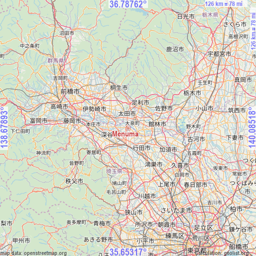
Menuma GPS coordinates[2]
36° 13' 20.82" North, 139° 22' 55.38" East
| Map corner | latitude | longitude |
|---|---|---|
| Upper-left | 36.78762°, | 138.67893° |
| Center: | 36.22245°, | 139.38205° |
| Lower-right: | 35.65317°, | 140.08518° |
| Map W x H: | 126.1×126.1 km | = 78.4×78.4mi |
| max Lat: | 45.40944° ⇑28.2% North |
| Menuma: | 36.22245° |
| min Lat: | ⇓71.8% South 24.34478° |
| min Long | Menuma | max Long |
| 123° | 139.38205° | 145.575° |
| W 65.9%⇐ | ⇒34.1% E |
Elevation
Elevation of Menuma is 29 m = 95 ft, and this is 55.6 m = 182 ft below average elevation for this country.
| Max E: |
1086 m = 3563 ft | 49.1% |
| Avg. | 84.6 m = 278 ft | |
| Menuma | 29 m = 95 ft | |
Min E: |
-2 m = -7 ft | 50.9% |
See also: Japan elevation on elevation.city.
Geographical zone
Menuma is located in North temperate zone (between Tropic of Cancer and the Arctic Circle). Distance of this Northern Tropic circle is 1421.6 km =883.3 mi to South.| Distance of | km | miles | from Menuma |
|---|---|---|---|
| North Pole | 5979.5 | 3715.5 | to North |
| Arctic Circle | 3373.6 | 2096.3 | to North |
| Tropic Cancer | 1421.6 | 883.3 | to South |
| Equator | 4027.6 | 2502.6 | to South |


Nearby cities:
15 places around Menuma: (largest is in red/bold)
• Ashikaga
13.8 km =8.6 mi,  26°
26°
• Fukaya
12 km =7.5 mi,  245°
245°
• Fukayachō
9.2 km =5.7 mi, 254°
• Fukiage-fujimi
14.9 km =9.3 mi,  155°
155°
• Gyōda
11.5 km =7.1 mi,  142°
142°
• Hanyū
14.9 km =9.3 mi,  114°
114°
• Honjō
17.3 km =10.7 mi,  275°
275°
• Isesaki
19.4 km =12.1 mi,  302°
302°
• Kiryū
20.2 km =12.6 mi,  347°
347°
• Kumagaya
9.8 km =6.1 mi,  175°
175°
• Sakai-nakajima
12.8 km =8 mi,  292°
292°
• Sano
20.9 km =13 mi,  59°
59°
• Tatebayashi
13.9 km =8.6 mi,  77°
77°
• Yorii
20.6 km =12.8 mi,  234°
234°
• Ōta
8.7 km =5.4 mi, 350°
Sources, notices
• [Note1] Compared only with cities in Japan existing in our database
• [Src1] Map data: © OpenStreetMap contributors (CC-BY-SA)
• [Src2] Other city data from geonames.org with taken over terms of usage.
• [Src3] Geographical zone / Annual Mean Temperature by Robert A. Rohde @ Wikipedia
