Fukaya geodata
Fukaya (Saitama) is a seat of a second-order administrative division; located in Japan in Asia/Tokyo (GMT+9) time zone. In our database, there are 767 cities with bigger population. Compared to other cities in Japan, 71% of cities are located further ↓South; 63.9% of cities are located further ←West and 70.1% of cities have lower elevation than Fukaya. Note1


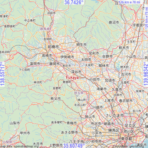
Fukaya GPS coordinates[2]
36° 10' 37.56" North, 139° 15' 37.044" East
| Map corner | latitude | longitude |
|---|---|---|
| Upper-left | 36.7426°, | 138.55717° |
| Center: | 36.1771°, | 139.26029° |
| Lower-right: | 35.60749°, | 139.96342° |
| Map W x H: | 126.2×126.2 km | = 78.4×78.4mi |
| max Lat: | 45.40944° ⇑29% North |
| Fukaya: | 36.1771° |
| min Lat: | ⇓71% South 24.34478° |
| min Long | Fukaya | max Long |
| 123° | 139.26029° | 145.575° |
| W 63.9%⇐ | ⇒36.1% E |
Elevation
Elevation of Fukaya is 72 m = 236 ft, and this is 12.6 m = 41 ft below average elevation for this country.
| Max E: |
1086 m = 3563 ft | 29.9% |
| Avg. | 84.6 m = 278 ft | |
| Fukaya | 72 m = 236 ft | |
Min E: |
-2 m = -7 ft | 70.1% |
See also: Japan elevation on elevation.city.
Geographical zone
Fukaya is located in North temperate zone (between Tropic of Cancer and the Arctic Circle). Distance of this Northern Tropic circle is 1416.6 km =880.2 mi to South.| Distance of | km | miles | from Fukaya |
|---|---|---|---|
| North Pole | 5984.5 | 3718.6 | to North |
| Arctic Circle | 3378.7 | 2099.4 | to North |
| Tropic Cancer | 1416.6 | 880.2 | to South |
| Equator | 4022.5 | 2499.5 | to South |


Nearby cities:
15 places around Fukaya: (largest is in red/bold)
• Fujioka
18.6 km =11.6 mi,  294°
294°
• Fukayachō
3.3 km =2.1 mi,  39°
39°
• Fukiage-fujimi
19.1 km =11.9 mi,  116°
116°
• Gyōda
18.4 km =11.4 mi,  102°
102°
• Higashi-Matsuyama
21.3 km =13.2 mi,  138°
138°
• Honjō
9.2 km =5.7 mi,  317°
317°
• Isesaki
16.4 km =10.2 mi,  340°
340°
• Kodamachō-kodamaminami
11.6 km =7.2 mi,  274°
274°
• Kumagaya
12.6 km =7.8 mi,  111°
111°
• Menuma
12 km =7.5 mi,  65°
65°
• Ogawa
13.8 km =8.6 mi,  177°
177°
• Sakai-nakajima
10 km =6.2 mi,  354°
354°
• Tamamura
18.8 km =11.7 mi, 316°
• Yorii
9 km =5.6 mi,  220°
220°
• Ōta
16.7 km =10.4 mi,  34°
34°
Sources, notices
• [Note1] Compared only with cities in Japan existing in our database
• [Src1] Map data: © OpenStreetMap contributors (CC-BY-SA)
• [Src2] Other city data from geonames.org with taken over terms of usage.
• [Src3] Geographical zone / Annual Mean Temperature by Robert A. Rohde @ Wikipedia
