Kiryū geodata
Kiryū (Gunma) is a seat of a second-order administrative division; located in Japan in Asia/Tokyo (GMT+9) time zone. With population of 110,219 people, there are 187 cities with bigger population in this country. Compared to other cities in Japan, 75.7% of cities are located further ↓South; 65% of cities are located further ←West and 78% of cities have lower elevation than Kiryū. Note1


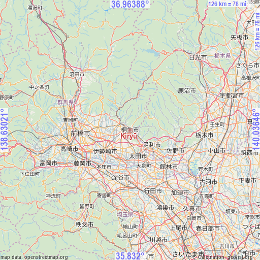
Kiryū GPS coordinates[2]
36° 24' 0" North, 139° 19' 59.988" East
| Map corner | latitude | longitude |
|---|---|---|
| Upper-left | 36.96388°, | 138.63021° |
| Center: | 36.4°, | 139.33333° |
| Lower-right: | 35.832°, | 140.03646° |
| Map W x H: | 125.9×125.9 km | = 78.2×78.2mi |
| max Lat: | 45.40944° ⇑24.3% North |
| Kiryū: | 36.4° |
| min Lat: | ⇓75.7% South 24.34478° |
| min Long | Kiryū | max Long |
| 123° | 139.33333° | 145.575° |
| W 65%⇐ | ⇒35% E |
Elevation
Elevation of Kiryū is 108 m = 354 ft, and this is 23.4 m = 77 ft above average elevation for this country.
| Max E: |
1086 m = 3563 ft | 22% |
| Kiryū | 108 m 354 ft | |
| Avg. | 84.6 m = 278 ft | |
Min E: |
-2 m = -7 ft | 78% |
See also: Kiryū elevation on elevation.city.
Geographical zone
Kiryū is located in North temperate zone (between Tropic of Cancer and the Arctic Circle). Distance of this Northern Tropic circle is 1441.4 km =895.6 mi to South.| Distance of | km | miles | from Kiryū |
|---|---|---|---|
| North Pole | 5959.8 | 3703.2 | to North |
| Arctic Circle | 3353.9 | 2084 | to North |
| Tropic Cancer | 1441.4 | 895.6 | to South |
| Equator | 4047.3 | 2514.9 | to South |


Nearby cities:
15 places around Kiryū: (largest is in red/bold)
• Ashikaga
12.8 km =8 mi,  125°
125°
• Fukaya
25.6 km =15.9 mi,  194°
194°
• Fukayachō
22.7 km =14.1 mi, 191°
• Honjō
22.1 km =13.7 mi,  215°
215°
• Isesaki
15.1 km =9.4 mi,  232°
232°
• Maebashi
22.4 km =13.9 mi,  270°
270°
• Menuma
20.2 km =12.6 mi,  167°
167°
• Midori
6.6 km =4.1 mi,  318°
318°
• Sakai-nakajima
16.6 km =10.3 mi,  206°
206°
• Sano
24.2 km =15 mi,  112°
112°
• Tamamura
22.4 km =13.9 mi,  240°
240°
• Tanuma
22.7 km =14.1 mi,  99°
99°
• Tatebayashi
24.5 km =15.2 mi, 132°
• Ōmamachō-ōmama
6.3 km =3.9 mi,  304°
304°
• Ōta
11.5 km =7.1 mi,  164°
164°
Sources, notices
• [Note1] Compared only with cities in Japan existing in our database
• [Src1] Map data: © OpenStreetMap contributors (CC-BY-SA)
• [Src2] Other city data from geonames.org with taken over terms of usage.
• [Src3] Geographical zone / Annual Mean Temperature by Robert A. Rohde @ Wikipedia
