Hioki geodata
Hioki (Kagoshima) is a seat of a second-order administrative division; located in Japan in Asia/Tokyo (GMT+9) time zone. In our database, there are 767 cities with bigger population. Compared to other cities in Japan, 96.5% of cities are located further ↑North; 94.7% of cities are located further →East and 95.3% of cities have higher elevation than Hioki. Note1


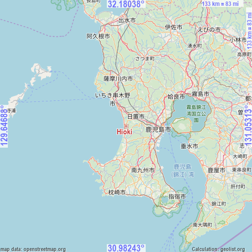
Hioki GPS coordinates[2]
31° 34' 59.988" North, 130° 21' 0" East
| Map corner | latitude | longitude |
|---|---|---|
| Upper-left | 32.18038°, | 129.64688° |
| Center: | 31.58333°, | 130.35° |
| Lower-right: | 30.98243°, | 131.05313° |
| Map W x H: | 133.2×133.2 km | = 82.8×82.8mi |
| max Lat: | 45.40944° ⇑96.5% North |
| Hioki: | 31.58333° |
| min Lat: | ⇓3.5% South 24.34478° |
| min Long | Hioki | max Long |
| 123° | 130.35° | 145.575° |
| W 5.3%⇐ | ⇒94.7% E |
Elevation
Elevation of Hioki is 3 m = 10 ft, and this is 81.6 m = 268 ft below average elevation for this country.
| Max E: |
1086 m = 3563 ft | 95.3% |
| Avg. | 84.6 m = 278 ft | |
| Hioki | 3 m = 10 ft | |
Min E: |
-2 m = -7 ft | 4.7% |
See also: Japan elevation on elevation.city.
Geographical zone
Hioki is located in North temperate zone (between Tropic of Cancer and the Arctic Circle). Distance of this Northern Tropic circle is 905.8 km =562.8 mi to South.| Distance of | km | miles | from Hioki |
|---|---|---|---|
| North Pole | 6495.3 | 4036 | to North |
| Arctic Circle | 3889.4 | 2416.8 | to North |
| Tropic Cancer | 905.8 | 562.8 | to South |
| Equator | 3511.7 | 2182.1 | to South |


Nearby cities:
15 places around Hioki: (largest is in red/bold)
• Aira
31.2 km =19.4 mi,  47°
47°
• Hamanoichi
39.2 km =24.4 mi,  67°
67°
• Ichikikushikino
17.1 km =10.6 mi,  341°
341°
• Ijūin
6 km =3.7 mi, 51°
• Kagoshima
19 km =11.8 mi,  95°
95°
• Kajiki
34.3 km =21.3 mi,  60°
60°
• Kaseda-shirakame
18.8 km =11.7 mi,  189°
189°
• Kirishima
42.8 km =26.6 mi, 65°
• Kokubu-matsuki
42.8 km =26.6 mi, 67°
• Kushikino
16.8 km =10.4 mi,  331°
331°
• Makurazaki
35.4 km =22 mi, 185°
• Minamikyushu
28.2 km =17.5 mi,  159°
159°
• Minamisatsuma
22.4 km =13.9 mi,  196°
196°
• Satsumasendai
26.4 km =16.4 mi,  349°
349°
• Tarumizu
35 km =21.7 mi,  108°
108°
Sources, notices
• [Note1] Compared only with cities in Japan existing in our database
• [Src1] Map data: © OpenStreetMap contributors (CC-BY-SA)
• [Src2] Other city data from geonames.org with taken over terms of usage.
• [Src3] Geographical zone / Annual Mean Temperature by Robert A. Rohde @ Wikipedia
