Kozakai-chō geodata
Kozakai-chō (Aichi) is a section of populated place; located in Japan in Asia/Tokyo (GMT+9) time zone. With population of 22,064 people, there are 660 cities with bigger population in this country. Compared to other cities in Japan, 64.9% of cities are located further ↑North; 50.9% of cities are located further ←West and 81.8% of cities have higher elevation than Kozakai-chō. Note1


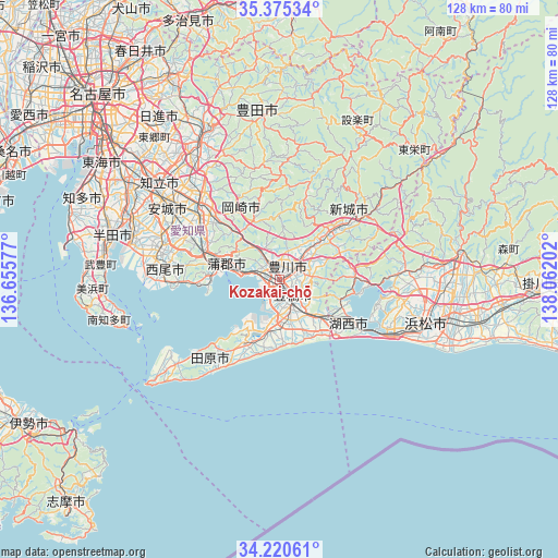
Kozakai-chō GPS coordinates[2]
34° 48' 0" North, 137° 21' 32.004" East
| Map corner | latitude | longitude |
|---|---|---|
| Upper-left | 35.37534°, | 136.65577° |
| Center: | 34.8°, | 137.35889° |
| Lower-right: | 34.22061°, | 138.06202° |
| Map W x H: | 128.4×128.4 km | = 79.8×79.8mi |
| max Lat: | 45.40944° ⇑64.9% North |
| Kozakai-chō: | 34.8° |
| min Lat: | ⇓35.1% South 24.34478° |
| min Long | Kozakai-chō | max Long |
| 123° | 137.35889° | 145.575° |
| W 50.9%⇐ | ⇒49.1% E |
Elevation
Elevation of Kozakai-chō is 7 m = 23 ft, and this is 77.6 m = 255 ft below average elevation for this country.
| Max E: |
1086 m = 3563 ft | 81.8% |
| Avg. | 84.6 m = 278 ft | |
| Kozakai-chō | 7 m = 23 ft | |
Min E: |
-2 m = -7 ft | 18.2% |
See also: Japan elevation on elevation.city.
Geographical zone
Kozakai-chō is located in North temperate zone (between Tropic of Cancer and the Arctic Circle). Distance of this Northern Tropic circle is 1263.5 km =785.1 mi to South.| Distance of | km | miles | from Kozakai-chō |
|---|---|---|---|
| North Pole | 6137.7 | 3813.8 | to North |
| Arctic Circle | 3531.8 | 2194.6 | to North |
| Tropic Cancer | 1263.5 | 785.1 | to South |
| Equator | 3869.4 | 2404.3 | to South |


Nearby cities:
15 places around Kozakai-chō: (largest is in red/bold)
• Anjō
30.9 km =19.2 mi,  304°
304°
• Gamagōri
12 km =7.5 mi,  287°
287°
• Hamamatsu
36 km =22.4 mi,  108°
108°
• Handayama
34.7 km =21.6 mi,  94°
94°
• Hekinan
35.5 km =22.1 mi, 285°
• Ishiki
31.2 km =19.4 mi,  270°
270°
• Kosai
18.6 km =11.6 mi,  126°
126°
• Nishio
29.1 km =18.1 mi,  284°
284°
• Okazaki
24.2 km =15 mi,  313°
313°
• Shinshiro
17 km =10.6 mi,  49°
49°
• Tahara
17.1 km =10.6 mi,  209°
209°
• Takahama
36.6 km =22.7 mi, 290°
• Toyohashi
4.3 km =2.7 mi,  148°
148°
• Toyokawa
4.2 km =2.6 mi,  63°
63°
• Toyota
36.8 km =22.9 mi,  328°
328°
Sources, notices
• [Note1] Compared only with cities in Japan existing in our database
• [Src1] Map data: © OpenStreetMap contributors (CC-BY-SA)
• [Src2] Other city data from geonames.org with taken over terms of usage.
• [Src3] Geographical zone / Annual Mean Temperature by Robert A. Rohde @ Wikipedia
