Kobe geodata
Kobe (Hyōgo) is a seat of a first-order administrative division; located in Japan in Asia/Tokyo (GMT+9) time zone. With population of 1,528,478 people, there are 5 cities with bigger population in this country. Compared to other cities in Japan, 68.5% of cities are located further ↑North; 69.8% of cities are located further →East and 54.9% of cities have lower elevation than Kobe. Note1


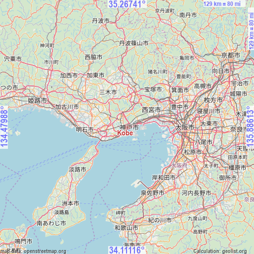
Kobe GPS coordinates[2]
34° 41' 28.68" North, 135° 10' 58.8" East
| Map corner | latitude | longitude |
|---|---|---|
| Upper-left | 35.26741°, | 134.47988° |
| Center: | 34.6913°, | 135.183° |
| Lower-right: | 34.11116°, | 135.88613° |
| Map W x H: | 128.6×128.6 km | = 79.9×79.9mi |
| max Lat: | 45.40944° ⇑68.5% North |
| Kobe: | 34.6913° |
| min Lat: | ⇓31.5% South 24.34478° |
| min Long | Kobe | max Long |
| 123° | 135.183° | 145.575° |
| W 30.2%⇐ | ⇒69.8% E |
Elevation
Elevation of Kobe is 35 m = 115 ft, and this is 49.6 m = 163 ft below average elevation for this country.
| Max E: |
1086 m = 3563 ft | 45.1% |
| Avg. | 84.6 m = 278 ft | |
| Kobe | 35 m = 115 ft | |
Min E: |
-2 m = -7 ft | 54.9% |
See also: Kobe elevation on elevation.city.
Geographical zone
Kobe is located in North temperate zone (between Tropic of Cancer and the Arctic Circle). Distance of this Northern Tropic circle is 1251.4 km =777.6 mi to South.| Distance of | km | miles | from Kobe |
|---|---|---|---|
| North Pole | 6149.8 | 3821.3 | to North |
| Arctic Circle | 3543.9 | 2202.1 | to North |
| Tropic Cancer | 1251.4 | 777.6 | to South |
| Equator | 3857.3 | 2396.8 | to South |


Nearby cities:
15 places around Kobe: (largest is in red/bold)
• Akashi
16.6 km =10.3 mi,  256°
256°
• Amagasaki
21.5 km =13.4 mi,  82°
82°
• Ashiya
11.7 km =7.3 mi,  69°
69°
• Ikeda
26.8 km =16.7 mi,  57°
57°
• Itami
22.5 km =14 mi, 62°
• Kawanishi
25.5 km =15.8 mi, 56°
• Kawanishi
28.9 km =18 mi,  43°
43°
• Miki
21.9 km =13.6 mi,  303°
303°
• Nishinomiya-hama
13.9 km =8.6 mi, 78°
• Ono
28.8 km =17.9 mi,  307°
307°
• Sakai
28.6 km =17.8 mi,  114°
114°
• Sanda
28.6 km =17.8 mi,  5°
5°
• Sandachō
21.8 km =13.5 mi, 10°
• Takarazuka
19.9 km =12.4 mi,  52°
52°
• Toyonaka
28.1 km =17.5 mi, 68°
In other languages:
- In Spanish: Kōbe
- In France: Kōbe
- In German: Kōbe, Kobe
- In Italian: Kōbe
- In Russian: Кобе
- In Chinese: 神户市
Sources, notices
• [Note1] Compared only with cities in Japan existing in our database
• [Src1] Map data: © OpenStreetMap contributors (CC-BY-SA)
• [Src2] Other city data from geonames.org with taken over terms of usage.
• [Src3] Geographical zone / Annual Mean Temperature by Robert A. Rohde @ Wikipedia
