Sandachō geodata
Sandachō (Hyōgo) is a populated place; located in Japan in Asia/Tokyo (GMT+9) time zone. With population of 132,858 people, there are 155 cities with bigger population in this country. Compared to other cities in Japan, 61.3% of cities are located further ↑North; 69.4% of cities are located further →East and 82.8% of cities have lower elevation than Sandachō. Note1


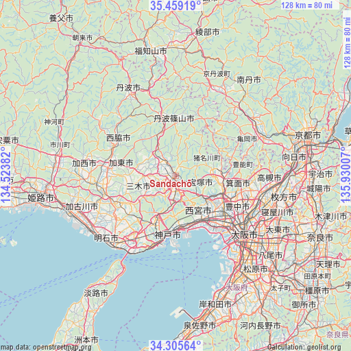
Sandachō GPS coordinates[2]
34° 53' 3.984" North, 135° 13' 36.984" East
| Map corner | latitude | longitude |
|---|---|---|
| Upper-left | 35.45919°, | 134.52382° |
| Center: | 34.88444°, | 135.22694° |
| Lower-right: | 34.30564°, | 135.93007° |
| Map W x H: | 128.3×128.3 km | = 79.7×79.7mi |
| max Lat: | 45.40944° ⇑61.3% North |
| Sandachō: | 34.88444° |
| min Lat: | ⇓38.7% South 24.34478° |
| min Long | Sandachō | max Long |
| 123° | 135.22694° | 145.575° |
| W 30.6%⇐ | ⇒69.4% E |
Elevation
Elevation of Sandachō is 147 m = 482 ft, and this is 62.4 m = 205 ft above average elevation for this country.
| Max E: |
1086 m = 3563 ft | 17.2% |
| Sandachō | 147 m 482 ft | |
| Avg. | 84.6 m = 278 ft | |
Min E: |
-2 m = -7 ft | 82.8% |
See also: Sandachō elevation on elevation.city.
Geographical zone
Sandachō is located in North temperate zone (between Tropic of Cancer and the Arctic Circle). Distance of this Northern Tropic circle is 1272.9 km =790.9 mi to South.| Distance of | km | miles | from Sandachō |
|---|---|---|---|
| North Pole | 6128.3 | 3807.9 | to North |
| Arctic Circle | 3522.4 | 2188.7 | to North |
| Tropic Cancer | 1272.9 | 790.9 | to South |
| Equator | 3878.8 | 2410.2 | to South |


Nearby cities:
15 places around Sandachō: (largest is in red/bold)
• Ashiya
18.7 km =11.6 mi,  158°
158°
• Ikeda
19.8 km =12.3 mi,  110°
110°
• Itami
19.4 km =12.1 mi,  124°
124°
• Katō
18.8 km =11.7 mi,  283°
283°
• Kawanishi
15.7 km =9.8 mi,  91°
91°
• Kawanishi
18.9 km =11.7 mi, 113°
• Kobe
21.8 km =13.5 mi,  190°
190°
• Miki
24.1 km =15 mi,  247°
247°
• Mino
23.1 km =14.4 mi, 106°
• Nishinomiya-hama
21.1 km =13.1 mi,  152°
152°
• Sanda
7.1 km =4.4 mi,  350°
350°
• Sasayama
20.3 km =12.6 mi,  357°
357°
• Takarazuka
15.2 km =9.4 mi,  128°
128°
• Toyonaka
24.9 km =15.5 mi, 117°
• Yashiro
24 km =14.9 mi, 278°
Sources, notices
• [Note1] Compared only with cities in Japan existing in our database
• [Src1] Map data: © OpenStreetMap contributors (CC-BY-SA)
• [Src2] Other city data from geonames.org with taken over terms of usage.
• [Src3] Geographical zone / Annual Mean Temperature by Robert A. Rohde @ Wikipedia
