Hōryūji geodata
Hōryūji (Nara) is a populated place; located in Japan in Asia/Tokyo (GMT+9) time zone. With population of 27,431 people, there are 576 cities with bigger population in this country. Compared to other cities in Japan, 70% of cities are located further ↑North; 63.8% of cities are located further →East and 61.6% of cities have lower elevation than Hōryūji. Note1


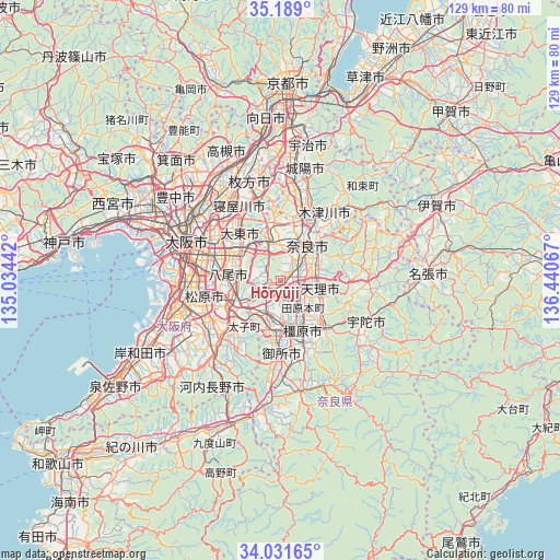
Hōryūji GPS coordinates[2]
34° 36' 44.424" North, 135° 44' 15.144" East
| Map corner | latitude | longitude |
|---|---|---|
| Upper-left | 35.189°, | 135.03442° |
| Center: | 34.61234°, | 135.73754° |
| Lower-right: | 34.03165°, | 136.44067° |
| Map W x H: | 128.7×128.7 km | = 80×80mi |
| max Lat: | 45.40944° ⇑70% North |
| Hōryūji: | 34.61234° |
| min Lat: | ⇓30% South 24.34478° |
| min Long | Hōryūji | max Long |
| 123° | 135.73754° | 145.575° |
| W 36.2%⇐ | ⇒63.8% E |
Elevation
Elevation of Hōryūji is 49 m = 161 ft, and this is 35.6 m = 117 ft below average elevation for this country.
| Max E: |
1086 m = 3563 ft | 38.4% |
| Avg. | 84.6 m = 278 ft | |
| Hōryūji | 49 m = 161 ft | |
Min E: |
-2 m = -7 ft | 61.6% |
See also: Japan elevation on elevation.city.
Geographical zone
Hōryūji is located in North temperate zone (between Tropic of Cancer and the Arctic Circle). Distance of this Northern Tropic circle is 1242.6 km =772.1 mi to South.| Distance of | km | miles | from Hōryūji |
|---|---|---|---|
| North Pole | 6158.5 | 3826.7 | to North |
| Arctic Circle | 3552.6 | 2207.5 | to North |
| Tropic Cancer | 1242.6 | 772.1 | to South |
| Equator | 3848.5 | 2391.3 | to South |


Nearby cities:
15 places around Hōryūji: (largest is in red/bold)
• Fujiidera
13.8 km =8.6 mi,  248°
248°
• Habikino
15 km =9.3 mi,  243°
243°
• Higashi-ōsaka
15.3 km =9.5 mi,  293°
293°
• Ikoma
8.6 km =5.3 mi,  336°
336°
• Kashiba
9 km =5.6 mi,  196°
196°
• Kashihara
11.5 km =7.1 mi, 253°
• Kashihara-shi
12.6 km =7.8 mi,  156°
156°
• Katsuragi
14.6 km =9.1 mi,  194°
194°
• Nara-shi
10.2 km =6.3 mi,  37°
37°
• Shijōnawate
14.3 km =8.9 mi, 339°
• Tawaramoto
8.2 km =5.1 mi,  141°
141°
• Tenri
9.3 km =5.8 mi,  110°
110°
• Yamato-Takada
10.7 km =6.6 mi,  173°
173°
• Yamatokōriyama
3.1 km =1.9 mi,  102°
102°
• Yao
12.6 km =7.8 mi,  272°
272°
Sources, notices
• [Note1] Compared only with cities in Japan existing in our database
• [Src1] Map data: © OpenStreetMap contributors (CC-BY-SA)
• [Src2] Other city data from geonames.org with taken over terms of usage.
• [Src3] Geographical zone / Annual Mean Temperature by Robert A. Rohde @ Wikipedia
