Nara-shi geodata
Nara-shi (Nara) is a seat of a first-order administrative division; located in Japan in Asia/Tokyo (GMT+9) time zone. With population of 367,353 people, there are 44 cities with bigger population in this country. Compared to other cities in Japan, 68.6% of cities are located further ↑North; 62.8% of cities are located further →East and 69.1% of cities have lower elevation than Nara-shi. Note1


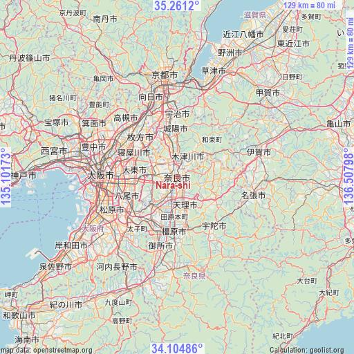
Nara-shi GPS coordinates[2]
34° 41' 6.18" North, 135° 48' 17.46" East
| Map corner | latitude | longitude |
|---|---|---|
| Upper-left | 35.2612°, | 135.10173° |
| Center: | 34.68505°, | 135.80485° |
| Lower-right: | 34.10486°, | 136.50798° |
| Map W x H: | 128.6×128.6 km | = 79.9×79.9mi |
| max Lat: | 45.40944° ⇑68.6% North |
| Nara-shi: | 34.68505° |
| min Lat: | ⇓31.4% South 24.34478° |
| min Long | Nara-shi | max Long |
| 123° | 135.80485° | 145.575° |
| W 37.2%⇐ | ⇒62.8% E |
Elevation
Elevation of Nara-shi is 68 m = 223 ft, and this is 16.6 m = 54 ft below average elevation for this country.
| Max E: |
1086 m = 3563 ft | 30.9% |
| Avg. | 84.6 m = 278 ft | |
| Nara-shi | 68 m = 223 ft | |
Min E: |
-2 m = -7 ft | 69.1% |
See also: Nara-shi elevation on elevation.city.
Geographical zone
Nara-shi is located in North temperate zone (between Tropic of Cancer and the Arctic Circle). Distance of this Northern Tropic circle is 1250.7 km =777.1 mi to South.| Distance of | km | miles | from Nara-shi |
|---|---|---|---|
| North Pole | 6150.4 | 3821.7 | to North |
| Arctic Circle | 3544.6 | 2202.5 | to North |
| Tropic Cancer | 1250.7 | 777.1 | to South |
| Equator | 3856.6 | 2396.4 | to South |


Nearby cities:
15 places around Nara-shi: (largest is in red/bold)
• Daitōchō
17.2 km =10.7 mi,  280°
280°
• Hōryūji
10.2 km =6.3 mi,  217°
217°
• Ikoma
9.6 km =6 mi,  268°
268°
• Jōyō
17.7 km =11 mi,  0°
0°
• Kashiba
18.9 km =11.7 mi,  207°
207°
• Katano
16.2 km =10.1 mi,  317°
317°
• Kizugawa
6.6 km =4.1 mi,  29°
29°
• Kyōtanabe
13.7 km =8.5 mi,  345°
345°
• Neyagawa
18.5 km =11.5 mi,  299°
299°
• Shijōnawate
12.3 km =7.6 mi, 295°
• Tanabe
15.7 km =9.8 mi, 346°
• Tawaramoto
14.6 km =9.1 mi,  184°
184°
• Tenri
11.6 km =7.2 mi,  167°
167°
• Yamato-Takada
19.4 km =12.1 mi,  195°
195°
• Yamatokōriyama
9.3 km =5.8 mi, 199°
In other languages:
- In Spanish: Nara
- In France: Nara
- In German: Nara
- In Italian: Nara
- In Russian: Нара
- In Chinese: 奈良市
Sources, notices
• [Note1] Compared only with cities in Japan existing in our database
• [Src1] Map data: © OpenStreetMap contributors (CC-BY-SA)
• [Src2] Other city data from geonames.org with taken over terms of usage.
• [Src3] Geographical zone / Annual Mean Temperature by Robert A. Rohde @ Wikipedia
