Yamatokōriyama geodata
Yamatokōriyama (Nara) is a seat of a second-order administrative division; located in Japan in Asia/Tokyo (GMT+9) time zone. In our database, there are 767 cities with bigger population. Compared to other cities in Japan, 70.1% of cities are located further ↑North; 63.1% of cities are located further →East and 58.2% of cities have lower elevation than Yamatokōriyama. Note1


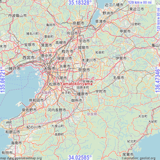
Yamatokōriyama GPS coordinates[2]
34° 36' 23.688" North, 135° 46' 13.188" East
| Map corner | latitude | longitude |
|---|---|---|
| Upper-left | 35.18328°, | 135.06721° |
| Center: | 34.60658°, | 135.77033° |
| Lower-right: | 34.02585°, | 136.47346° |
| Map W x H: | 128.7×128.7 km | = 80×80mi |
| max Lat: | 45.40944° ⇑70.1% North |
| Yamatokōriyama: | 34.60658° |
| min Lat: | ⇓29.9% South 24.34478° |
| min Long | Yamatokōriyama | max Long |
| 123° | 135.77033° | 145.575° |
| W 36.9%⇐ | ⇒63.1% E |
Elevation
Elevation of Yamatokōriyama is 42 m = 138 ft, and this is 42.6 m = 140 ft below average elevation for this country.
| Max E: |
1086 m = 3563 ft | 41.8% |
| Avg. | 84.6 m = 278 ft | |
| Yamatokōriyama | 42 m = 138 ft | |
Min E: |
-2 m = -7 ft | 58.2% |
See also: Japan elevation on elevation.city.
Geographical zone
Yamatokōriyama is located in North temperate zone (between Tropic of Cancer and the Arctic Circle). Distance of this Northern Tropic circle is 1242 km =771.7 mi to South.| Distance of | km | miles | from Yamatokōriyama |
|---|---|---|---|
| North Pole | 6159.2 | 3827.1 | to North |
| Arctic Circle | 3553.3 | 2207.9 | to North |
| Tropic Cancer | 1242 | 771.7 | to South |
| Equator | 3847.9 | 2391 | to South |


Nearby cities:
15 places around Yamatokōriyama: (largest is in red/bold)
• Fujiidera
16.4 km =10.2 mi,  254°
254°
• Hōryūji
3.1 km =1.9 mi,  282°
282°
• Ikoma
10.7 km =6.6 mi,  322°
322°
• Kashiba
9.8 km =6.1 mi,  214°
214°
• Kashihara
14.3 km =8.9 mi,  259°
259°
• Kashihara-shi
11 km =6.8 mi,  169°
169°
• Katsuragi
15 km =9.3 mi, 206°
• Kizugawa
15.8 km =9.8 mi,  23°
23°
• Nara-shi
9.3 km =5.8 mi, 19°
• Sakurai
13.9 km =8.6 mi,  148°
148°
• Shijōnawate
16.2 km =10.1 mi,  330°
330°
• Tawaramoto
6.2 km =3.9 mi,  160°
160°
• Tenri
6.3 km =3.9 mi,  114°
114°
• Yamato-Takada
10.2 km =6.3 mi,  190°
190°
• Yao
15.6 km =9.7 mi,  274°
274°
Sources, notices
• [Note1] Compared only with cities in Japan existing in our database
• [Src1] Map data: © OpenStreetMap contributors (CC-BY-SA)
• [Src2] Other city data from geonames.org with taken over terms of usage.
• [Src3] Geographical zone / Annual Mean Temperature by Robert A. Rohde @ Wikipedia
