Hakui geodata
Hakui (Ishikawa) is a seat of a second-order administrative division; located in Japan in Asia/Tokyo (GMT+9) time zone. With population of 24,529 people, there are 618 cities with bigger population in this country. Compared to other cities in Japan, 81.6% of cities are located further ↓South; 55.2% of cities are located further →East and 86% of cities have higher elevation than Hakui. Note1


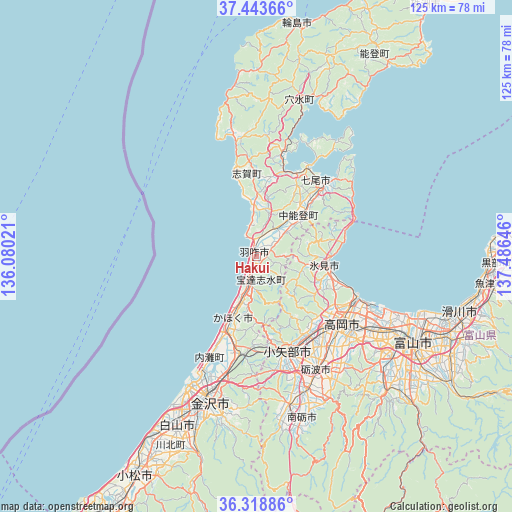
Hakui GPS coordinates[2]
36° 52' 59.988" North, 136° 46' 59.988" East
| Map corner | latitude | longitude |
|---|---|---|
| Upper-left | 37.44366°, | 136.08021° |
| Center: | 36.88333°, | 136.78333° |
| Lower-right: | 36.31886°, | 137.48646° |
| Map W x H: | 125.1×125.1 km | = 77.7×77.7mi |
| max Lat: | 45.40944° ⇑18.4% North |
| Hakui: | 36.88333° |
| min Lat: | ⇓81.6% South 24.34478° |
| min Long | Hakui | max Long |
| 123° | 136.78333° | 145.575° |
| W 44.8%⇐ | ⇒55.2% E |
Elevation
Elevation of Hakui is 6 m = 20 ft, and this is 78.6 m = 258 ft below average elevation for this country.
| Max E: |
1086 m = 3563 ft | 86% |
| Avg. | 84.6 m = 278 ft | |
| Hakui | 6 m = 20 ft | |
Min E: |
-2 m = -7 ft | 14% |
See also: Japan elevation on elevation.city.
Geographical zone
Hakui is located in North temperate zone (between Tropic of Cancer and the Arctic Circle). Distance of this Northern Tropic circle is 1495.1 km =929 mi to South.| Distance of | km | miles | from Hakui |
|---|---|---|---|
| North Pole | 5906 | 3669.8 | to North |
| Arctic Circle | 3300.1 | 2050.6 | to North |
| Tropic Cancer | 1495.1 | 929 | to South |
| Equator | 4101 | 2548.2 | to South |


Nearby cities:
15 places around Hakui: (largest is in red/bold)
• Fukumitsu
37 km =23 mi,  168°
168°
• Himi
18.3 km =11.4 mi,  102°
102°
• Himimachi
18.5 km =11.5 mi, 99°
• Imizu
33 km =20.5 mi,  112°
112°
• Kahoku
15.4 km =9.6 mi,  204°
204°
• Kanazawa
34.8 km =21.6 mi,  205°
205°
• Nanao
24.7 km =15.3 mi,  41°
41°
• Nanto
42.4 km =26.3 mi, 166°
• Nanto-shi
36.7 km =22.8 mi,  161°
161°
• Nishishinminato
28.5 km =17.7 mi, 113°
• Nonoichi
41.7 km =25.9 mi, 200°
• Oyabe
24.8 km =15.4 mi, 166°
• Takaoka
25.5 km =15.8 mi,  125°
125°
• Tonami
32.5 km =20.2 mi,  154°
154°
• Tsubata
24 km =14.9 mi,  189°
189°
Sources, notices
• [Note1] Compared only with cities in Japan existing in our database
• [Src1] Map data: © OpenStreetMap contributors (CC-BY-SA)
• [Src2] Other city data from geonames.org with taken over terms of usage.
• [Src3] Geographical zone / Annual Mean Temperature by Robert A. Rohde @ Wikipedia
