Himimachi geodata
Himimachi (Toyama) is a populated place; located in Japan in Asia/Tokyo (GMT+9) time zone. With population of 54,510 people, there are 353 cities with bigger population in this country. Compared to other cities in Japan, 81.4% of cities are located further ↓South; 51.7% of cities are located further →East and 89.6% of cities have higher elevation than Himimachi. Note1


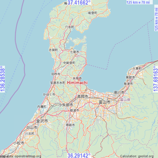
Himimachi GPS coordinates[2]
36° 51' 21.924" North, 136° 59' 18.6" East
| Map corner | latitude | longitude |
|---|---|---|
| Upper-left | 37.41662°, | 136.28538° |
| Center: | 36.85609°, | 136.9885° |
| Lower-right: | 36.29142°, | 137.69163° |
| Map W x H: | 125.1×125.1 km | = 77.7×77.7mi |
| max Lat: | 45.40944° ⇑18.6% North |
| Himimachi: | 36.85609° |
| min Lat: | ⇓81.4% South 24.34478° |
| min Long | Himimachi | max Long |
| 123° | 136.9885° | 145.575° |
| W 48.3%⇐ | ⇒51.7% E |
Elevation
Elevation of Himimachi is 5 m = 16 ft, and this is 79.6 m = 261 ft below average elevation for this country.
| Max E: |
1086 m = 3563 ft | 89.6% |
| Avg. | 84.6 m = 278 ft | |
| Himimachi | 5 m = 16 ft | |
Min E: |
-2 m = -7 ft | 10.4% |
See also: Himimachi elevation on elevation.city.
Geographical zone
Himimachi is located in North temperate zone (between Tropic of Cancer and the Arctic Circle). Distance of this Northern Tropic circle is 1492.1 km =927.1 mi to South.| Distance of | km | miles | from Himimachi |
|---|---|---|---|
| North Pole | 5909 | 3671.7 | to North |
| Arctic Circle | 3303.2 | 2052.5 | to North |
| Tropic Cancer | 1492.1 | 927.1 | to South |
| Equator | 4098 | 2546.4 | to South |


Nearby cities:
15 places around Himimachi: (largest is in red/bold)
• Fukumitsu
34.9 km =21.7 mi,  197°
197°
• Hakui
18.5 km =11.5 mi,  279°
279°
• Himi
1.1 km =0.7 mi, 202°
• Imizu
15.6 km =9.7 mi,  128°
128°
• Kahoku
27 km =16.8 mi,  246°
246°
• Namerikawa
34.9 km =21.7 mi,  107°
107°
• Nanao
21.6 km =13.4 mi,  354°
354°
• Nanto-shi
32.6 km =20.3 mi,  192°
192°
• Nishishinminato
11.5 km =7.1 mi,  137°
137°
• Oyabe
24.4 km =15.2 mi,  210°
210°
• Takaoka
12.1 km =7.5 mi,  167°
167°
• Tonami
26.5 km =16.5 mi, 188°
• Toyama
26.7 km =16.6 mi, 130°
• Tsubata
30.3 km =18.8 mi,  226°
226°
• Yatsuomachi-higashikumisaka
34.7 km =21.6 mi,  158°
158°
Sources, notices
• [Note1] Compared only with cities in Japan existing in our database
• [Src1] Map data: © OpenStreetMap contributors (CC-BY-SA)
• [Src2] Other city data from geonames.org with taken over terms of usage.
• [Src3] Geographical zone / Annual Mean Temperature by Robert A. Rohde @ Wikipedia
