Imizu geodata
Imizu (Toyama) is a seat of a second-order administrative division; located in Japan in Asia/Tokyo (GMT+9) time zone. In our database, there are 767 cities with bigger population. Compared to other cities in Japan, 80.7% of cities are located further ↓South; 50.5% of cities are located further →East and 95.3% of cities have higher elevation than Imizu. Note1


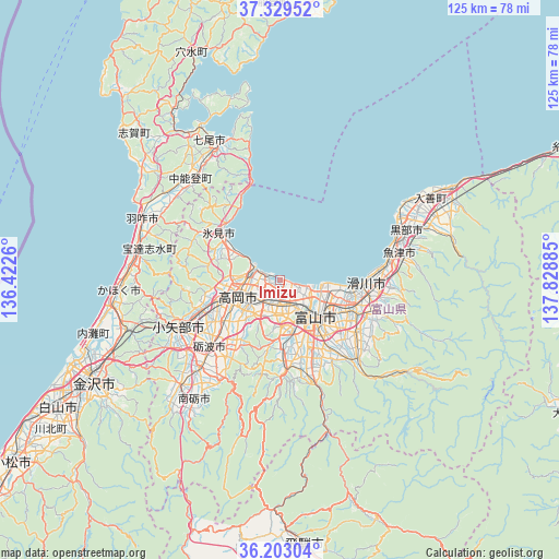
Imizu GPS coordinates[2]
36° 46' 6.06" North, 137° 7' 32.592" East
| Map corner | latitude | longitude |
|---|---|---|
| Upper-left | 37.32952°, | 136.4226° |
| Center: | 36.76835°, | 137.12572° |
| Lower-right: | 36.20304°, | 137.82885° |
| Map W x H: | 125.3×125.3 km | = 77.9×77.9mi |
| max Lat: | 45.40944° ⇑19.3% North |
| Imizu: | 36.76835° |
| min Lat: | ⇓80.7% South 24.34478° |
| min Long | Imizu | max Long |
| 123° | 137.12572° | 145.575° |
| W 49.5%⇐ | ⇒50.5% E |
Elevation
Elevation of Imizu is 3 m = 10 ft, and this is 81.6 m = 268 ft below average elevation for this country.
| Max E: |
1086 m = 3563 ft | 95.3% |
| Avg. | 84.6 m = 278 ft | |
| Imizu | 3 m = 10 ft | |
Min E: |
-2 m = -7 ft | 4.7% |
See also: Japan elevation on elevation.city.
Geographical zone
Imizu is located in North temperate zone (between Tropic of Cancer and the Arctic Circle). Distance of this Northern Tropic circle is 1482.3 km =921.1 mi to South.| Distance of | km | miles | from Imizu |
|---|---|---|---|
| North Pole | 5918.8 | 3677.8 | to North |
| Arctic Circle | 3312.9 | 2058.5 | to North |
| Tropic Cancer | 1482.3 | 921.1 | to South |
| Equator | 4088.3 | 2540.4 | to South |


Nearby cities:
15 places around Imizu: (largest is in red/bold)
• Fukumitsu
32.7 km =20.3 mi,  224°
224°
• Hakui
33 km =20.5 mi,  292°
292°
• Himi
15.4 km =9.6 mi,  304°
304°
• Himimachi
15.6 km =9.7 mi,  308°
308°
• Kamiichi
22.8 km =14.2 mi,  109°
109°
• Kurobe-shi
32.4 km =20.1 mi,  62°
62°
• Namerikawa
21.1 km =13.1 mi,  92°
92°
• Nanto-shi
29.2 km =18.1 mi, 220°
• Nishishinminato
4.6 km =2.9 mi, 285°
• Oyabe
27.1 km =16.8 mi,  245°
245°
• Takaoka
9.9 km =6.2 mi,  258°
258°
• Tonami
23.1 km =14.4 mi, 224°
• Toyama
11.1 km =6.9 mi,  133°
133°
• Uozu
24.7 km =15.3 mi,  81°
81°
• Yatsuomachi-higashikumisaka
22.4 km =13.9 mi,  178°
178°
Sources, notices
• [Note1] Compared only with cities in Japan existing in our database
• [Src1] Map data: © OpenStreetMap contributors (CC-BY-SA)
• [Src2] Other city data from geonames.org with taken over terms of usage.
• [Src3] Geographical zone / Annual Mean Temperature by Robert A. Rohde @ Wikipedia
