Tonami geodata
Tonami (Toyama) is a seat of a second-order administrative division; located in Japan in Asia/Tokyo (GMT+9) time zone. In our database, there are 767 cities with bigger population. Compared to other cities in Japan, 78.8% of cities are located further ↓South; 52.6% of cities are located further →East and 66.4% of cities have lower elevation than Tonami. Note1


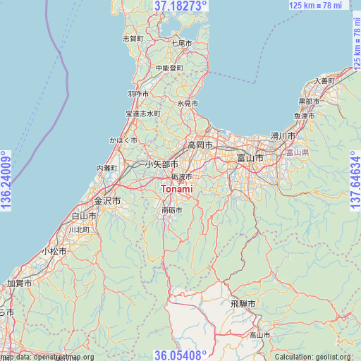
Tonami GPS coordinates[2]
36° 37' 13.692" North, 136° 56' 35.556" East
| Map corner | latitude | longitude |
|---|---|---|
| Upper-left | 37.18273°, | 136.24009° |
| Center: | 36.62047°, | 136.94321° |
| Lower-right: | 36.05408°, | 137.64634° |
| Map W x H: | 125.5×125.5 km | = 78×78mi |
| max Lat: | 45.40944° ⇑21.2% North |
| Tonami: | 36.62047° |
| min Lat: | ⇓78.8% South 24.34478° |
| min Long | Tonami | max Long |
| 123° | 136.94321° | 145.575° |
| W 47.4%⇐ | ⇒52.6% E |
Elevation
Elevation of Tonami is 61 m = 200 ft, and this is 23.6 m = 77 ft below average elevation for this country.
| Max E: |
1086 m = 3563 ft | 33.6% |
| Avg. | 84.6 m = 278 ft | |
| Tonami | 61 m = 200 ft | |
Min E: |
-2 m = -7 ft | 66.4% |
See also: Japan elevation on elevation.city.
Geographical zone
Tonami is located in North temperate zone (between Tropic of Cancer and the Arctic Circle). Distance of this Northern Tropic circle is 1465.9 km =910.9 mi to South.| Distance of | km | miles | from Tonami |
|---|---|---|---|
| North Pole | 5935.2 | 3688 | to North |
| Arctic Circle | 3329.4 | 2068.8 | to North |
| Tropic Cancer | 1465.9 | 910.9 | to South |
| Equator | 4071.8 | 2530.1 | to South |


Nearby cities:
15 places around Tonami: (largest is in red/bold)
• Fukumitsu
9.6 km =6 mi,  223°
223°
• Himi
25.4 km =15.8 mi,  8°
8°
• Himimachi
26.5 km =16.5 mi, 8°
• Imizu
23.1 km =14.4 mi,  44°
44°
• Kahoku
25.7 km =16 mi,  306°
306°
• Kanazawa
29.2 km =18.1 mi,  265°
265°
• Nanto
12.8 km =8 mi,  200°
200°
• Nanto-shi
6.4 km =4 mi,  206°
206°
• Nishishinminato
21.3 km =13.2 mi,  33°
33°
• Nonoichi
30.7 km =19.1 mi,  251°
251°
• Oyabe
9.8 km =6.1 mi,  301°
301°
• Takaoka
15.8 km =9.8 mi,  24°
24°
• Toyama
25.9 km =16.1 mi,  70°
70°
• Tsubata
18.9 km =11.7 mi,  286°
286°
• Yatsuomachi-higashikumisaka
18 km =11.2 mi,  109°
109°
Sources, notices
• [Note1] Compared only with cities in Japan existing in our database
• [Src1] Map data: © OpenStreetMap contributors (CC-BY-SA)
• [Src2] Other city data from geonames.org with taken over terms of usage.
• [Src3] Geographical zone / Annual Mean Temperature by Robert A. Rohde @ Wikipedia
