Bungo-ōno geodata
Bungo-ōno (Oita) is a seat of a second-order administrative division; located in Japan in Asia/Tokyo (GMT+9) time zone. In our database, there are 767 cities with bigger population. Compared to other cities in Japan, 91.1% of cities are located further ↑North; 84.1% of cities are located further →East and 89.1% of cities have lower elevation than Bungo-ōno. Note1


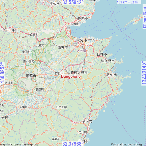
Bungo-ōno GPS coordinates[2]
32° 58' 17.472" North, 131° 31' 41.952" East
| Map corner | latitude | longitude |
|---|---|---|
| Upper-left | 33.55942°, | 130.8252° |
| Center: | 32.97152°, | 131.52832° |
| Lower-right: | 32.37968°, | 132.23145° |
| Map W x H: | 131.2×131.2 km | = 81.5×81.5mi |
| max Lat: | 45.40944° ⇑91.1% North |
| Bungo-ōno: | 32.97152° |
| min Lat: | ⇓8.9% South 24.34478° |
| min Long | Bungo-ōno | max Long |
| 123° | 131.52832° | 145.575° |
| W 15.9%⇐ | ⇒84.1% E |
Elevation
Elevation of Bungo-ōno is 206 m = 676 ft, and this is 121.4 m = 398 ft above average elevation for this country.
| Max E: |
1086 m = 3563 ft | 10.9% |
| Bungo-ōno | 206 m 676 ft | |
| Avg. | 84.6 m = 278 ft | |
Min E: |
-2 m = -7 ft | 89.1% |
See also: Japan elevation on elevation.city.
Geographical zone
Bungo-ōno is located in North temperate zone (between Tropic of Cancer and the Arctic Circle). Distance of this Northern Tropic circle is 1060.2 km =658.8 mi to South.| Distance of | km | miles | from Bungo-ōno |
|---|---|---|---|
| North Pole | 6341 | 3940.1 | to North |
| Arctic Circle | 3735.1 | 2320.9 | to North |
| Tropic Cancer | 1060.2 | 658.8 | to South |
| Equator | 3666.1 | 2278 | to South |


Nearby cities:
15 places around Bungo-ōno: (largest is in red/bold)
• Aso
42 km =26.1 mi,  264°
264°
• Beppu
34.4 km =21.4 mi,  355°
355°
• Hiji
44.4 km =27.6 mi,  0°
0°
• Kitsuki
50.6 km =31.4 mi,  9°
9°
• Nobeoka
45.1 km =28 mi,  163°
163°
• Saiki
34.8 km =21.6 mi,  93°
93°
• Takedamachi
12 km =7.5 mi,  267°
267°
• Taketa
15.1 km =9.4 mi, 264°
• Tsukawaki
48.5 km =30.1 mi,  314°
314°
• Tsukumiura
33.8 km =21 mi,  70°
70°
• Tsurusaki
34 km =21.1 mi,  26°
26°
• Usa
55 km =34.2 mi,  341°
341°
• Usuki
30.7 km =19.1 mi,  56°
56°
• Yufu
28.6 km =17.8 mi,  330°
330°
• Ōita
29.9 km =18.6 mi, 12°
Sources, notices
• [Note1] Compared only with cities in Japan existing in our database
• [Src1] Map data: © OpenStreetMap contributors (CC-BY-SA)
• [Src2] Other city data from geonames.org with taken over terms of usage.
• [Src3] Geographical zone / Annual Mean Temperature by Robert A. Rohde @ Wikipedia
