Takedamachi geodata
Takedamachi (Oita) is a section of populated place; located in Japan in Asia/Tokyo (GMT+9) time zone. With population of 16,361 people, there are 733 cities with bigger population in this country. Compared to other cities in Japan, 91.2% of cities are located further ↑North; 85% of cities are located further →East and 91.9% of cities have lower elevation than Takedamachi. Note1


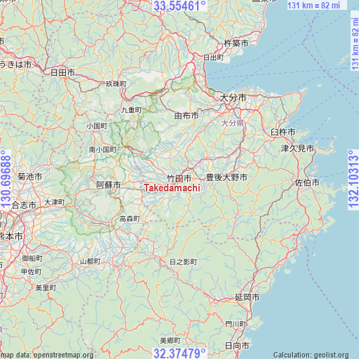
Takedamachi GPS coordinates[2]
32° 58' 0.012" North, 131° 24' 0" East
| Map corner | latitude | longitude |
|---|---|---|
| Upper-left | 33.55461°, | 130.69688° |
| Center: | 32.96667°, | 131.4° |
| Lower-right: | 32.37479°, | 132.10313° |
| Map W x H: | 131.2×131.2 km | = 81.5×81.5mi |
| max Lat: | 45.40944° ⇑91.2% North |
| Takedamachi: | 32.96667° |
| min Lat: | ⇓8.8% South 24.34478° |
| min Long | Takedamachi | max Long |
| 123° | 131.4° | 145.575° |
| W 15%⇐ | ⇒85% E |
Elevation
Elevation of Takedamachi is 262 m = 860 ft, and this is 177.4 m = 582 ft above average elevation for this country.
| Max E: |
1086 m = 3563 ft | 8.1% |
| Takedamachi | 262 m 860 ft | |
| Avg. | 84.6 m = 278 ft | |
Min E: |
-2 m = -7 ft | 91.9% |
See also: Japan elevation on elevation.city.
Geographical zone
Takedamachi is located in North temperate zone (between Tropic of Cancer and the Arctic Circle). Distance of this Northern Tropic circle is 1059.6 km =658.4 mi to South.| Distance of | km | miles | from Takedamachi |
|---|---|---|---|
| North Pole | 6341.5 | 3940.4 | to North |
| Arctic Circle | 3735.6 | 2321.2 | to North |
| Tropic Cancer | 1059.6 | 658.4 | to South |
| Equator | 3665.6 | 2277.7 | to South |


Nearby cities:
15 places around Takedamachi: (largest is in red/bold)
• Aso
30 km =18.6 mi,  263°
263°
• Beppu
35.9 km =22.3 mi,  14°
14°
• Bungo-ōno
12 km =7.5 mi,  87°
87°
• Hiji
46.5 km =28.9 mi,  15°
15°
• Nobeoka
49.4 km =30.7 mi,  149°
149°
• Saiki
46.7 km =29 mi, 92°
• Taketa
3.2 km =2 mi, 255°
• Tsukawaki
41.3 km =25.7 mi,  326°
326°
• Tsukumiura
45.4 km =28.2 mi,  74°
74°
• Tsurusaki
41.2 km =25.6 mi,  41°
41°
• Usa
52.9 km =32.9 mi,  353°
353°
• Usuki
41.5 km =25.8 mi, 65°
• Yufu
25.5 km =15.8 mi,  355°
355°
• Ōita
35 km =21.7 mi,  32°
32°
• Ōzu
50.2 km =31.2 mi, 258°
Sources, notices
• [Note1] Compared only with cities in Japan existing in our database
• [Src1] Map data: © OpenStreetMap contributors (CC-BY-SA)
• [Src2] Other city data from geonames.org with taken over terms of usage.
• [Src3] Geographical zone / Annual Mean Temperature by Robert A. Rohde @ Wikipedia
