Shiroi geodata
Shiroi (Chiba) is a seat of a second-order administrative division; located in Japan in Asia/Tokyo (GMT+9) time zone. With population of 55,314 people, there are 349 cities with bigger population in this country. Compared to other cities in Japan, 61.8% of cities are located further ↓South; 79.8% of cities are located further ←West and 62.8% of cities have higher elevation than Shiroi. Note1


Shiroi GPS coordinates[2]
35° 48' 0" North, 140° 4' 0.012" East
| Map corner | latitude | longitude |
|---|---|---|
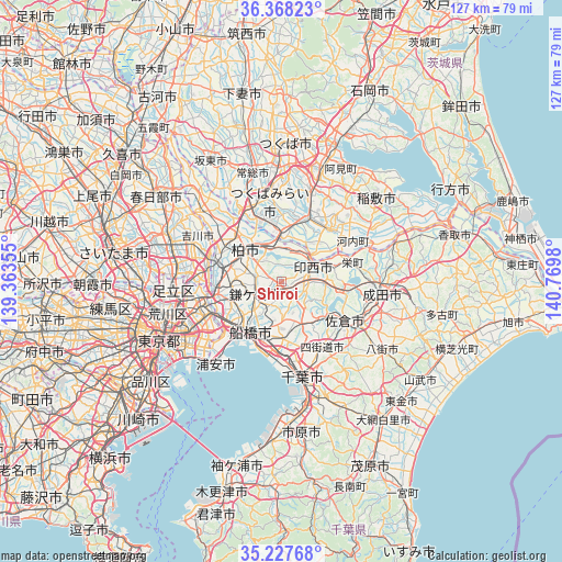
| Upper-left | 36.36823°, | 139.36355° |
| Center: | 35.8°, | 140.06667° |
| Lower-right: | 35.22768°, | 140.7698° |
| Map W x H: | 126.8×126.8 km | = 78.8×78.8mi |
| max Lat: | 45.40944° ⇑38.2% North |
| Shiroi: | 35.8° |
| min Lat: | ⇓61.8% South 24.34478° |
| min Long | Shiroi | max Long |
| 123° | 140.06667° | 145.575° |
| W 79.8%⇐ | ⇒20.2% E |
Elevation
Elevation of Shiroi is 17 m = 56 ft, and this is 67.6 m = 222 ft below average elevation for this country.
| Max E: |
1086 m = 3563 ft | 62.8% |
| Avg. | 84.6 m = 278 ft | |
| Shiroi | 17 m = 56 ft | |
Min E: |
-2 m = -7 ft | 37.2% |
See also: Shiroi elevation on elevation.city.
Geographical zone
Shiroi is located in North temperate zone (between Tropic of Cancer and the Arctic Circle). Distance of this Northern Tropic circle is 1374.7 km =854.2 mi to South.| Distance of | km | miles | from Shiroi |
|---|---|---|---|
| North Pole | 6026.5 | 3744.7 | to North |
| Arctic Circle | 3420.6 | 2125.5 | to North |
| Tropic Cancer | 1374.7 | 854.2 | to South |
| Equator | 3980.6 | 2473.4 | to South |


Nearby cities:
15 places around Shiroi: (largest is in red/bold)
• Abiko
8.7 km =5.4 mi,  328°
328°
• Fujishiro
13.7 km =8.5 mi,  19°
19°
• Funabashi
10.2 km =6.3 mi,  209°
209°
• Honchō
13.1 km =8.1 mi, 213°
• Ichikawa-minami
16.8 km =10.4 mi,  240°
240°
• Inzai
9.6 km =6 mi,  66°
66°
• Kamagaya
6.7 km =4.2 mi, 239°
• Kashiwa
10.6 km =6.6 mi,  310°
310°
• Matsudo
15.1 km =9.4 mi,  261°
261°
• Moriya
16 km =9.9 mi,  337°
337°
• Nagareyama
16.1 km =10 mi,  292°
292°
• Narashino
13.3 km =8.3 mi,  189°
189°
• Ryūgasaki
15.3 km =9.5 mi,  43°
43°
• Toride
11.2 km =7 mi,  7°
7°
• Yachiyo
8.9 km =5.5 mi,  144°
144°
Sources, notices
• [Note1] Compared only with cities in Japan existing in our database
• [Src1] Map data: © OpenStreetMap contributors (CC-BY-SA)
• [Src2] Other city data from geonames.org with taken over terms of usage.
• [Src3] Geographical zone / Annual Mean Temperature by Robert A. Rohde @ Wikipedia
