Honchō geodata
Honchō (Chiba) is a section of populated place; located in Japan in Asia/Tokyo (GMT+9) time zone. With population of 560,743 people, there are 21 cities with bigger population in this country. Compared to other cities in Japan, 58.3% of cities are located further ↓South; 78.3% of cities are located further ←West and 71.1% of cities have higher elevation than Honchō. Note1


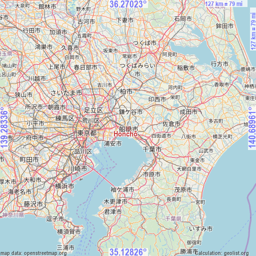
Honchō GPS coordinates[2]
35° 42' 4.644" North, 139° 59' 11.328" East
| Map corner | latitude | longitude |
|---|---|---|
| Upper-left | 36.27023°, | 139.28336° |
| Center: | 35.70129°, | 139.98648° |
| Lower-right: | 35.12826°, | 140.68961° |
| Map W x H: | 127×127 km | = 78.9×78.9mi |
| max Lat: | 45.40944° ⇑41.7% North |
| Honchō: | 35.70129° |
| min Lat: | ⇓58.3% South 24.34478° |
| min Long | Honchō | max Long |
| 123° | 139.98648° | 145.575° |
| W 78.3%⇐ | ⇒21.7% E |
Elevation
Elevation of Honchō is 11 m = 36 ft, and this is 73.6 m = 241 ft below average elevation for this country.
| Max E: |
1086 m = 3563 ft | 71.1% |
| Avg. | 84.6 m = 278 ft | |
| Honchō | 11 m = 36 ft | |
Min E: |
-2 m = -7 ft | 28.9% |
See also: Honchō elevation on elevation.city.
Geographical zone
Honchō is located in North temperate zone (between Tropic of Cancer and the Arctic Circle). Distance of this Northern Tropic circle is 1363.7 km =847.4 mi to South.| Distance of | km | miles | from Honchō |
|---|---|---|---|
| North Pole | 6037.5 | 3751.5 | to North |
| Arctic Circle | 3431.6 | 2132.3 | to North |
| Tropic Cancer | 1363.7 | 847.4 | to South |
| Equator | 3969.6 | 2466.6 | to South |


Nearby cities:
15 places around Honchō: (largest is in red/bold)
• Abiko
18.6 km =11.6 mi,  8°
8°
• Chiba
16.3 km =10.1 mi,  133°
133°
• Funabashi
3.1 km =1.9 mi,  46°
46°
• Ichikawa-minami
8 km =5 mi,  290°
290°
• Kamagaya
7.7 km =4.8 mi, 10°
• Kashiwa
17.9 km =11.1 mi,  357°
357°
• Matsudo
11.6 km =7.2 mi,  318°
318°
• Misato
18.4 km =11.4 mi,  329°
329°
• Nagareyama
18.8 km =11.7 mi,  336°
336°
• Narashino
5.4 km =3.4 mi,  113°
113°
• Shiroi
13.1 km =8.1 mi,  33°
33°
• Urayasu
9.5 km =5.9 mi,  248°
248°
• Urayasu
10 km =6.2 mi,  228°
228°
• Yachiyo
13 km =8.1 mi,  73°
73°
• Yotsukaidō
17.2 km =10.7 mi, 109°
Sources, notices
• [Note1] Compared only with cities in Japan existing in our database
• [Src1] Map data: © OpenStreetMap contributors (CC-BY-SA)
• [Src2] Other city data from geonames.org with taken over terms of usage.
• [Src3] Geographical zone / Annual Mean Temperature by Robert A. Rohde @ Wikipedia
