Kamagaya geodata
Kamagaya (Chiba) is a seat of a second-order administrative division; located in Japan in Asia/Tokyo (GMT+9) time zone. In our database, there are 767 cities with bigger population. Compared to other cities in Japan, 61.2% of cities are located further ↓South; 78.7% of cities are located further ←West and 52.4% of cities have lower elevation than Kamagaya. Note1


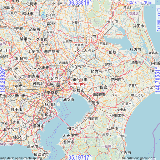
Kamagaya GPS coordinates[2]
35° 46' 10.956" North, 140° 0' 8.568" East
| Map corner | latitude | longitude |
|---|---|---|
| Upper-left | 36.33816°, | 139.29926° |
| Center: | 35.76971°, | 140.00238° |
| Lower-right: | 35.19717°, | 140.70551° |
| Map W x H: | 126.9×126.9 km | = 78.9×78.9mi |
| max Lat: | 45.40944° ⇑38.8% North |
| Kamagaya: | 35.76971° |
| min Lat: | ⇓61.2% South 24.34478° |
| min Long | Kamagaya | max Long |
| 123° | 140.00238° | 145.575° |
| W 78.7%⇐ | ⇒21.3% E |
Elevation
Elevation of Kamagaya is 31 m = 102 ft, and this is 53.6 m = 176 ft below average elevation for this country.
| Max E: |
1086 m = 3563 ft | 47.6% |
| Avg. | 84.6 m = 278 ft | |
| Kamagaya | 31 m = 102 ft | |
Min E: |
-2 m = -7 ft | 52.4% |
See also: Japan elevation on elevation.city.
Geographical zone
Kamagaya is located in North temperate zone (between Tropic of Cancer and the Arctic Circle). Distance of this Northern Tropic circle is 1371.3 km =852.1 mi to South.| Distance of | km | miles | from Kamagaya |
|---|---|---|---|
| North Pole | 6029.8 | 3746.7 | to North |
| Arctic Circle | 3424 | 2127.6 | to North |
| Tropic Cancer | 1371.3 | 852.1 | to South |
| Equator | 3977.2 | 2471.3 | to South |


Nearby cities:
15 places around Kamagaya: (largest is in red/bold)
• Abiko
10.9 km =6.8 mi,  6°
6°
• Funabashi
5.5 km =3.4 mi,  171°
171°
• Honchō
7.7 km =4.8 mi,  190°
190°
• Ichikawa-minami
10.1 km =6.3 mi,  241°
241°
• Inzai
16.2 km =10.1 mi,  63°
63°
• Kashiwa
10.5 km =6.5 mi,  347°
347°
• Matsudo
9.2 km =5.7 mi,  277°
277°
• Misato
13.5 km =8.4 mi,  307°
307°
• Nagareyama
13.2 km =8.2 mi,  316°
316°
• Narashino
10.4 km =6.5 mi,  160°
160°
• Shiroi
6.7 km =4.2 mi, 59°
• Toride
16.2 km =10.1 mi,  26°
26°
• Urayasu
15.1 km =9.4 mi,  222°
222°
• Yachiyo
11.7 km =7.3 mi,  109°
109°
• Yashio
15.9 km =9.9 mi,  291°
291°
Sources, notices
• [Note1] Compared only with cities in Japan existing in our database
• [Src1] Map data: © OpenStreetMap contributors (CC-BY-SA)
• [Src2] Other city data from geonames.org with taken over terms of usage.
• [Src3] Geographical zone / Annual Mean Temperature by Robert A. Rohde @ Wikipedia
