Funabashi geodata
Funabashi (Chiba) is a seat of a second-order administrative division; located in Japan in Asia/Tokyo (GMT+9) time zone. In our database, there are 767 cities with bigger population. Compared to other cities in Japan, 59.2% of cities are located further ↓South; 78.9% of cities are located further ←West and 56.6% of cities have higher elevation than Funabashi. Note1


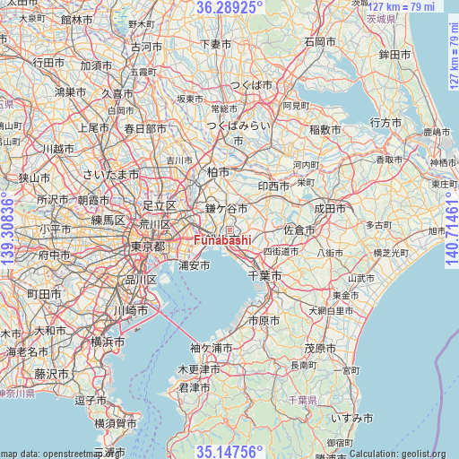
Funabashi GPS coordinates[2]
35° 43' 13.62" North, 140° 0' 41.328" East
| Map corner | latitude | longitude |
|---|---|---|
| Upper-left | 36.28925°, | 139.30836° |
| Center: | 35.72045°, | 140.01148° |
| Lower-right: | 35.14756°, | 140.71461° |
| Map W x H: | 126.9×126.9 km | = 78.9×78.9mi |
| max Lat: | 45.40944° ⇑40.8% North |
| Funabashi: | 35.72045° |
| min Lat: | ⇓59.2% South 24.34478° |
| min Long | Funabashi | max Long |
| 123° | 140.01148° | 145.575° |
| W 78.9%⇐ | ⇒21.1% E |
Elevation
Elevation of Funabashi is 22 m = 72 ft, and this is 62.6 m = 205 ft below average elevation for this country.
| Max E: |
1086 m = 3563 ft | 56.6% |
| Avg. | 84.6 m = 278 ft | |
| Funabashi | 22 m = 72 ft | |
Min E: |
-2 m = -7 ft | 43.4% |
See also: Japan elevation on elevation.city.
Geographical zone
Funabashi is located in North temperate zone (between Tropic of Cancer and the Arctic Circle). Distance of this Northern Tropic circle is 1365.8 km =848.7 mi to South.| Distance of | km | miles | from Funabashi |
|---|---|---|---|
| North Pole | 6035.3 | 3750.2 | to North |
| Arctic Circle | 3429.4 | 2130.9 | to North |
| Tropic Cancer | 1365.8 | 848.7 | to South |
| Equator | 3971.7 | 2467.9 | to South |


Nearby cities:
15 places around Funabashi: (largest is in red/bold)
• Abiko
16.3 km =10.1 mi,  1°
1°
• Chiba
16.4 km =10.2 mi,  144°
144°
• Honchō
3.1 km =1.9 mi,  226°
226°
• Ichikawa-minami
9.7 km =6 mi,  273°
273°
• Kamagaya
5.5 km =3.4 mi,  351°
351°
• Kashiwa
16.1 km =10 mi, 348°
• Matsudo
11.9 km =7.4 mi,  303°
303°
• Misato
17.9 km =11.1 mi,  319°
319°
• Nagareyama
18 km =11.2 mi,  326°
326°
• Narashino
5.1 km =3.2 mi,  147°
147°
• Shiroi
10.2 km =6.3 mi,  29°
29°
• Urayasu
12.4 km =7.7 mi,  243°
243°
• Urayasu
13.1 km =8.1 mi, 228°
• Yachiyo
10.3 km =6.4 mi,  80°
80°
• Yotsukaidō
16.1 km =10 mi,  119°
119°
Sources, notices
• [Note1] Compared only with cities in Japan existing in our database
• [Src1] Map data: © OpenStreetMap contributors (CC-BY-SA)
• [Src2] Other city data from geonames.org with taken over terms of usage.
• [Src3] Geographical zone / Annual Mean Temperature by Robert A. Rohde @ Wikipedia
