Yamagata geodata
Yamagata is a seat of a first-order administrative division; located in Japan in Asia/Tokyo (GMT+9) time zone. With population of 254,538 people, there are 80 cities with bigger population in this country. Compared to other cities in Japan, 88.1% of cities are located further ↓South; 84.1% of cities are located further ←West and 93.7% of cities have lower elevation than Yamagata. Note1


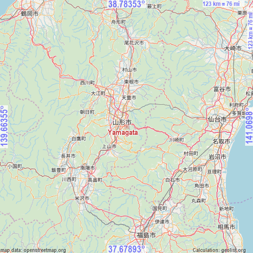
Yamagata GPS coordinates[2]
38° 13' 59.988" North, 140° 22' 0.012" East
| Map corner | latitude | longitude |
|---|---|---|
| Upper-left | 38.78353°, | 139.66355° |
| Center: | 38.23333°, | 140.36667° |
| Lower-right: | 37.67893°, | 141.0698° |
| Map W x H: | 122.8×122.8 km | = 76.3×76.3mi |
| max Lat: | 45.40944° ⇑11.9% North |
| Yamagata: | 38.23333° |
| min Lat: | ⇓88.1% South 24.34478° |
| min Long | Yamagata | max Long |
| 123° | 140.36667° | 145.575° |
| W 84.1%⇐ | ⇒15.9% E |
Elevation
Elevation of Yamagata is 321 m = 1053 ft, and this is 236.4 m = 776 ft above average elevation for this country.
| Max E: |
1086 m = 3563 ft | 6.3% |
| Yamagata | 321 m 1053 ft | |
| Avg. | 84.6 m = 278 ft | |
Min E: |
-2 m = -7 ft | 93.7% |
See also: Yamagata elevation on elevation.city.
Geographical zone
Yamagata is located in North temperate zone (between Tropic of Cancer and the Arctic Circle). Distance of this Northern Tropic circle is 1645.2 km =1022.3 mi to South.| Distance of | km | miles | from Yamagata |
|---|---|---|---|
| North Pole | 5755.9 | 3576.5 | to North |
| Arctic Circle | 3150 | 1957.3 | to North |
| Tropic Cancer | 1645.2 | 1022.3 | to South |
| Equator | 4251.1 | 2641.5 | to South |


Nearby cities:
15 places around Yamagata: (largest is in red/bold)
• Higashine
23 km =14.3 mi,  7°
7°
• Iwanuma
45.4 km =28.2 mi,  108°
108°
• Kaminoyama
12 km =7.5 mi,  222°
222°
• Murayama
26.6 km =16.5 mi, 8°
• Nagai
32.4 km =20.1 mi,  243°
243°
• Nanyō
30.7 km =19.1 mi,  226°
226°
• Natori-shi
45.7 km =28.4 mi,  99°
99°
• Obanazawa
41.3 km =25.7 mi,  4°
4°
• Sagae
17.5 km =10.9 mi,  332°
332°
• Sendai
43.8 km =27.2 mi,  85°
85°
• Shiroishi
33.7 km =20.9 mi,  139°
139°
• Takahata
29.9 km =18.6 mi,  210°
210°
• Tendō
13.4 km =8.3 mi, 1°
• Yonezawa
42.1 km =26.2 mi, 211°
• Ōkawara
38 km =23.6 mi,  122°
122°
Sources, notices
• [Note1] Compared only with cities in Japan existing in our database
• [Src1] Map data: © OpenStreetMap contributors (CC-BY-SA)
• [Src2] Other city data from geonames.org with taken over terms of usage.
• [Src3] Geographical zone / Annual Mean Temperature by Robert A. Rohde @ Wikipedia
