Rifu geodata
Rifu (Miyagi) is a populated place; located in Japan in Asia/Tokyo (GMT+9) time zone. With population of 35,037 people, there are 497 cities with bigger population in this country. Compared to other cities in Japan, 88.5% of cities are located further ↓South; 92.3% of cities are located further ←West and 81.8% of cities have higher elevation than Rifu. Note1


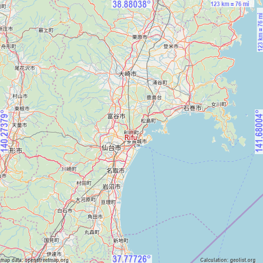
Rifu GPS coordinates[2]
38° 19' 51.312" North, 140° 58' 36.876" East
| Map corner | latitude | longitude |
|---|---|---|
| Upper-left | 38.88038°, | 140.27379° |
| Center: | 38.33092°, | 140.97691° |
| Lower-right: | 37.77726°, | 141.68004° |
| Map W x H: | 122.7×122.7 km | = 76.2×76.2mi |
| max Lat: | 45.40944° ⇑11.5% North |
| Rifu: | 38.33092° |
| min Lat: | ⇓88.5% South 24.34478° |
| min Long | Rifu | max Long |
| 123° | 140.97691° | 145.575° |
| W 92.3%⇐ | ⇒7.7% E |
Elevation
Elevation of Rifu is 7 m = 23 ft, and this is 77.6 m = 255 ft below average elevation for this country.
| Max E: |
1086 m = 3563 ft | 81.8% |
| Avg. | 84.6 m = 278 ft | |
| Rifu | 7 m = 23 ft | |
Min E: |
-2 m = -7 ft | 18.2% |
See also: Japan elevation on elevation.city.
Geographical zone
Rifu is located in North temperate zone (between Tropic of Cancer and the Arctic Circle). Distance of this Northern Tropic circle is 1656.1 km =1029.1 mi to South.| Distance of | km | miles | from Rifu |
|---|---|---|---|
| North Pole | 5745.1 | 3569.8 | to North |
| Arctic Circle | 3139.2 | 1950.6 | to North |
| Tropic Cancer | 1656.1 | 1029.1 | to South |
| Equator | 4262 | 2648.3 | to South |


Nearby cities:
15 places around Rifu: (largest is in red/bold)
• Furukawa
26.8 km =16.7 mi,  356°
356°
• Higashimatsushima
19.6 km =12.2 mi,  63°
63°
• Ishinomaki
29.7 km =18.5 mi,  71°
71°
• Iwanuma
27.2 km =16.9 mi,  202°
202°
• Kogota
25.2 km =15.7 mi,  14°
14°
• Matsushima
8.7 km =5.4 mi, 57°
• Natori-shi
20 km =12.4 mi, 204°
• Sendai
12 km =7.5 mi,  233°
233°
• Shiogama
5.2 km =3.2 mi,  107°
107°
• Tagajō-shi
4 km =2.5 mi,  149°
149°
• Tomiya
10.5 km =6.5 mi,  311°
311°
• Wakuya
27.4 km =17 mi,  30°
30°
• Watari
34.7 km =21.6 mi, 198°
• Yamoto
23.4 km =14.5 mi, 62°
• Ōsaki
28.7 km =17.8 mi, 359°
Sources, notices
• [Note1] Compared only with cities in Japan existing in our database
• [Src1] Map data: © OpenStreetMap contributors (CC-BY-SA)
• [Src2] Other city data from geonames.org with taken over terms of usage.
• [Src3] Geographical zone / Annual Mean Temperature by Robert A. Rohde @ Wikipedia
