Utsunomiya geodata
Utsunomiya (Tochigi) is a seat of a first-order administrative division; located in Japan in Asia/Tokyo (GMT+9) time zone. With population of 449,865 people, there are 29 cities with bigger population in this country. Compared to other cities in Japan, 78.3% of cities are located further ↓South; 76% of cities are located further ←West and 81.7% of cities have lower elevation than Utsunomiya. Note1


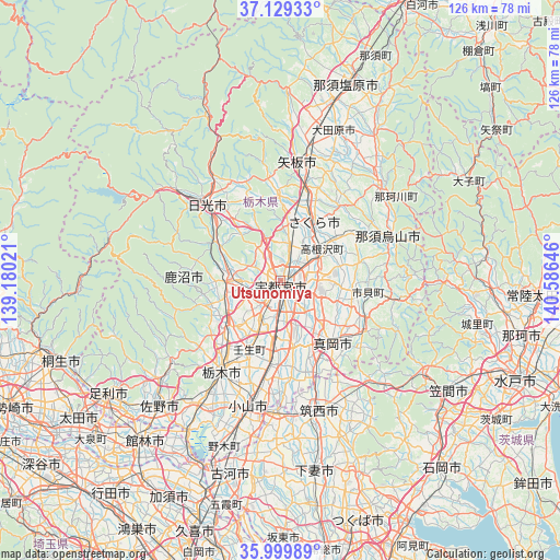
Utsunomiya GPS coordinates[2]
36° 34' 0.012" North, 139° 52' 59.988" East
| Map corner | latitude | longitude |
|---|---|---|
| Upper-left | 37.12933°, | 139.18021° |
| Center: | 36.56667°, | 139.88333° |
| Lower-right: | 35.99989°, | 140.58646° |
| Map W x H: | 125.6×125.6 km | = 78×78mi |
| max Lat: | 45.40944° ⇑21.7% North |
| Utsunomiya: | 36.56667° |
| min Lat: | ⇓78.3% South 24.34478° |
| min Long | Utsunomiya | max Long |
| 123° | 139.88333° | 145.575° |
| W 76%⇐ | ⇒24% E |
Elevation
Elevation of Utsunomiya is 137 m = 449 ft, and this is 52.4 m = 172 ft above average elevation for this country.
| Max E: |
1086 m = 3563 ft | 18.3% |
| Utsunomiya | 137 m 449 ft | |
| Avg. | 84.6 m = 278 ft | |
Min E: |
-2 m = -7 ft | 81.7% |
See also: Utsunomiya elevation on elevation.city.
Geographical zone
Utsunomiya is located in North temperate zone (between Tropic of Cancer and the Arctic Circle). Distance of this Northern Tropic circle is 1459.9 km =907.1 mi to South.| Distance of | km | miles | from Utsunomiya |
|---|---|---|---|
| North Pole | 5941.2 | 3691.7 | to North |
| Arctic Circle | 3335.3 | 2072.5 | to North |
| Tropic Cancer | 1459.9 | 907.1 | to South |
| Equator | 4065.8 | 2526.4 | to South |


Nearby cities:
15 places around Utsunomiya: (largest is in red/bold)
• Chikusei
29.2 km =18.1 mi,  162°
162°
• Imaichi
24.4 km =15.2 mi,  313°
313°
• Kaminokawa
15.1 km =9.4 mi,  168°
168°
• Kanuma
13.5 km =8.4 mi,  262°
262°
• Karasuyama
25.5 km =15.8 mi,  68°
68°
• Mashiko
22.3 km =13.9 mi,  119°
119°
• Mibu
18.3 km =11.4 mi,  204°
204°
• Mooka
19 km =11.8 mi,  141°
141°
• Motegi
27.4 km =17 mi,  101°
101°
• Nasukarasuyama
26.5 km =16.5 mi, 68°
• Sakura
19.5 km =12.1 mi,  28°
28°
• Shimotsuke
17.1 km =10.6 mi,  185°
185°
• Tochigi
24.4 km =15.2 mi,  213°
213°
• Ujiie
15 km =9.3 mi, 29°
• Yaita
26.3 km =16.3 mi,  9°
9°
Sources, notices
• [Note1] Compared only with cities in Japan existing in our database
• [Src1] Map data: © OpenStreetMap contributors (CC-BY-SA)
• [Src2] Other city data from geonames.org with taken over terms of usage.
• [Src3] Geographical zone / Annual Mean Temperature by Robert A. Rohde @ Wikipedia
