Motegi geodata
Motegi (Tochigi) is a populated place; located in Japan in Asia/Tokyo (GMT+9) time zone. With population of 19,575 people, there are 702 cities with bigger population in this country. Compared to other cities in Japan, 77.4% of cities are located further ↓South; 81.8% of cities are located further ←West and 77% of cities have lower elevation than Motegi. Note1


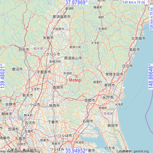
Motegi GPS coordinates[2]
36° 31' 0.012" North, 140° 10' 59.988" East
| Map corner | latitude | longitude |
|---|---|---|
| Upper-left | 37.07969°, | 139.48021° |
| Center: | 36.51667°, | 140.18333° |
| Lower-right: | 35.94952°, | 140.88646° |
| Map W x H: | 125.7×125.7 km | = 78.1×78.1mi |
| max Lat: | 45.40944° ⇑22.6% North |
| Motegi: | 36.51667° |
| min Lat: | ⇓77.4% South 24.34478° |
| min Long | Motegi | max Long |
| 123° | 140.18333° | 145.575° |
| W 81.8%⇐ | ⇒18.2% E |
Elevation
Elevation of Motegi is 105 m = 344 ft, and this is 20.4 m = 67 ft above average elevation for this country.
| Max E: |
1086 m = 3563 ft | 23% |
| Motegi | 105 m 344 ft | |
| Avg. | 84.6 m = 278 ft | |
Min E: |
-2 m = -7 ft | 77% |
See also: Japan elevation on elevation.city.
Geographical zone
Motegi is located in North temperate zone (between Tropic of Cancer and the Arctic Circle). Distance of this Northern Tropic circle is 1454.4 km =903.7 mi to South.| Distance of | km | miles | from Motegi |
|---|---|---|---|
| North Pole | 5946.8 | 3695.2 | to North |
| Arctic Circle | 3340.9 | 2075.9 | to North |
| Tropic Cancer | 1454.4 | 903.7 | to South |
| Equator | 4060.3 | 2523 | to South |


Nearby cities:
15 places around Motegi: (largest is in red/bold)
• Chikusei
28.7 km =17.8 mi,  218°
218°
• Hitachiomiya
20.3 km =12.6 mi,  74°
74°
• Iwase
20 km =12.4 mi,  201°
201°
• Kaminokawa
25.6 km =15.9 mi,  248°
248°
• Karasuyama
15.1 km =9.4 mi,  348°
348°
• Kasama
16.6 km =10.3 mi,  153°
153°
• Makabe
28.8 km =17.9 mi, 195°
• Mashiko
9.3 km =5.8 mi,  233°
233°
• Mooka
17.5 km =10.9 mi,  238°
238°
• Nasukarasuyama
15.2 km =9.4 mi, 352°
• Sakura
28.6 km =17.8 mi,  322°
322°
• Tomobe
21.3 km =13.2 mi, 150°
• Ujiie
26.8 km =16.7 mi,  313°
313°
• Utsunomiya
27.4 km =17 mi,  281°
281°
• Ōmiya
21.2 km =13.2 mi,  79°
79°
Sources, notices
• [Note1] Compared only with cities in Japan existing in our database
• [Src1] Map data: © OpenStreetMap contributors (CC-BY-SA)
• [Src2] Other city data from geonames.org with taken over terms of usage.
• [Src3] Geographical zone / Annual Mean Temperature by Robert A. Rohde @ Wikipedia
