Iwanai geodata
Iwanai (Hokkaido) is a populated place; located in Japan in Asia/Tokyo (GMT+9) time zone. With population of 15,584 people, there are 738 cities with bigger population in this country. Compared to other cities in Japan, 96.7% of cities are located further ↓South; 87.3% of cities are located further ←West and 86% of cities have higher elevation than Iwanai. Note1


Iwanai GPS coordinates[2]
42° 58' 27.984" North, 140° 30' 32.004" East
| Map corner | latitude | longitude |
|---|---|---|
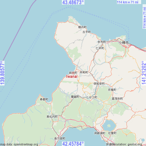
| Upper-left | 43.48673°, | 139.80577° |
| Center: | 42.97444°, | 140.50889° |
| Lower-right: | 42.45784°, | 141.21202° |
| Map W x H: | 114.4×114.4 km | = 71.1×71.1mi |
| max Lat: | 45.40944° ⇑3.3% North |
| Iwanai: | 42.97444° |
| min Lat: | ⇓96.7% South 24.34478° |
| min Long | Iwanai | max Long |
| 123° | 140.50889° | 145.575° |
| W 87.3%⇐ | ⇒12.7% E |
Elevation
Elevation of Iwanai is 6 m = 20 ft, and this is 78.6 m = 258 ft below average elevation for this country.
| Max E: |
1086 m = 3563 ft | 86% |
| Avg. | 84.6 m = 278 ft | |
| Iwanai | 6 m = 20 ft | |
Min E: |
-2 m = -7 ft | 14% |
See also: Japan elevation on elevation.city.
Geographical zone
Iwanai is located in North temperate zone (between Tropic of Cancer and the Arctic Circle). Distance of this Northern Tropic circle is 2172.4 km =1349.9 mi to South.| Distance of | km | miles | from Iwanai |
|---|---|---|---|
| North Pole | 5228.8 | 3249 | to North |
| Arctic Circle | 2622.9 | 1629.8 | to North |
| Tropic Cancer | 2172.4 | 1349.9 | to South |
| Equator | 4778.3 | 2969.1 | to South |


Nearby cities:
15 places around Iwanai: (largest is in red/bold)
• Chitose
94.7 km =58.8 mi,  100°
100°
• Date
63.5 km =39.5 mi,  152°
152°
• Ebetsu
85.9 km =53.4 mi,  80°
80°
• Eniwa
87.3 km =54.2 mi, 95°
• Ishikari
74.7 km =46.4 mi,  66°
66°
• Kitahiroshima
86.1 km =53.5 mi,  89°
89°
• Muroran
82.9 km =51.5 mi, 151°
• Niseko Town
25.4 km =15.8 mi, 149°
• Noboribetsu
79.8 km =49.6 mi,  136°
136°
• Otaru
46.7 km =29 mi,  59°
59°
• Sapporo
69.1 km =42.9 mi, 81°
• Shiraoi
83.3 km =51.8 mi,  124°
124°
• Tomakomai
96.8 km =60.1 mi,  112°
112°
• Tōbetsu
86.2 km =53.6 mi, 71°
• Yoichi
33.2 km =20.6 mi,  39°
39°
Sources, notices
• [Note1] Compared only with cities in Japan existing in our database
• [Src1] Map data: © OpenStreetMap contributors (CC-BY-SA)
• [Src2] Other city data from geonames.org with taken over terms of usage.
• [Src3] Geographical zone / Annual Mean Temperature by Robert A. Rohde @ Wikipedia
